

Orca: Boat GPS, Charts, Routes
October 02, 2024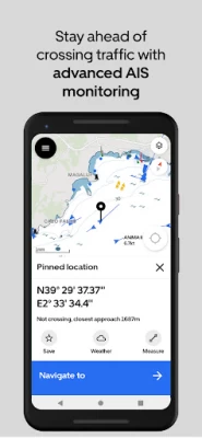
More About Orca: Boat GPS, Charts, Routes
* Modern chart design to maximize legibility.
* Satellite Maps to ease your approaches
* Tailored routes for Sailboats and Powerboats
* Most comprehensive AIS data feed
* Global Marine Weather forecast with Temperature, Wind, Tides and Currents
* Add the Orca Core to get boat integration - Instruments, Auto Pilot remote control and Radar Integration
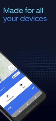
Works across all platforms - on your phone, tablet, Apple Watch and Orca Display.
Orca is the next-generation boating system that runs on your mobile and tablet, and on your boat. Experience the award-winning boating app for free.
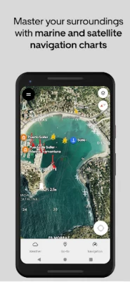
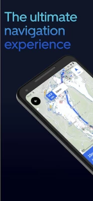
CAPTIVATING MARINE CHARTS
Orca's next-generation charts are crisp, easy to read, and respond instantly. High-resolution satellite marine charts make harbor entries and anchoring easier than ever.
Orca combines the best of paper chart design with a cutting-edge chart engine. Far ahead of anything else you've tried, Orca gives you charts the most responsive and beautiful charts on the market. No matter how fast you zoom, pan and rotate, the Orca charts will keep up and show you what you need.
Our satellite hybrid charts blend high-resolution satellite imagery with marine chart data to give you an even better understanding of harbor approaches and challenging navigation maneuvers.
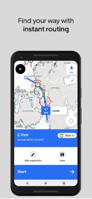
INCREDIBLE ROUTEFINDING
Set your destination, and Orca will find the way instantly. Routes are tailored for your boat and Orca learns from you and other boaters, so you can navigate like a local no matter where you are.
A true generation-leap, the Orca Routing Engine analyzes millions of data points in the blink of an eye to give you great, tailor-made routes to your destination.
GLOBAL AIS
Orca integrates MarineTraffic AIS feed to provide you with the most comprehensive AIS solution in a navigation app. Over 400 000 boats are tracked in real-time with extended information such as Images.
FLEXIBLE INSTRUMENTS
Get instruments for your phone, tablet and Orca Display. Connect to thousands of devices, from transducers to wind sensors and AIS receivers. Tailor instruments just the way you like them – with perfect legibility day and night.
CONNECTIVITY THAT MATTERS
While Orca is fully capable offline, it truly shines online. Seamlessly sync routes and spots between your devices. View hyper-local weather forecasts with down-to-the-minute forecasts for your exact location. Get notifications before rainfall or other bad weather while underway.
Orca is also clever. It monitors your upcoming trips and notifies you if the forecast changes for the worse so you can prepare and make changes if needed.
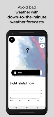
ONE STEP AHEAD OF BAD WEATHER
Weather is the difference between a perfect and a stressful day at sea. It is why weather forecasts are deeply ingrained in the Orca experience. Down-to-the-minute marine weather forecasts help you plan your trips and find the best departure time. While you are underway, the Orca keeps an eye on the weather and sends you real-time alerts if forecasts change.
YOU ARE IN GOOD COMPANY
Orca is used by boaters worldwide, onboard RIBs, day cruisers, and sailboats. Some use the Orca Core to unlock powerful navigation features on their tablet and phone. Others get the marine-grade Orca Display for a robust and reliable experience in demanding conditions.
No matter what you want, you can be sure you’ll get a truly modern, powerful, and incredible boating experience with Orca.
A COMPLETE NAVIGATION EXPERIENCE
The Orca App can be used as a standalone planning system. For those who want more, get an Orca Core to unlock a full chartplotter experience on your mobile device.
The Core is delivered with a high-precision GPS and compass, giving you a more accurate and reliable boating experience.
Connect the hub to your existing NMEA 2000 to view instrument data, AIS targets, and control your autopilot – all from your phone and tablet.
Join the modern way of boating. Join Orca.
Latest Version
1.0.157
October 02, 2024
Orca Technologies AS
Internet
Android
103,658
Free
com.theorca.slate
Report a Problem
User Reviews

Jasmin Klaić
1 year ago
great free app thank you 🙏

Hugo Maturana
1 year ago
When I try to set up a route , it keeps saying unable to navigate, Start point is outside chart coverage. Am trying the Sydney Harbour.

Jon mcstea
1 year ago
brilliant to have on your phone

Simon
1 year ago
Superb range of tools and information

Rock
1 year ago
It is absolutely worthless if you are anywhere North of Ottawa on the Ottawa river

Jorg Lovoll
2 years ago
it may take time to get used to my new Orca map plotter. The map is ok, but my hardware has so far failed to show speed data. I have contacted the dealer and hope they have a fix for it.

Will O'Reilly
2 years ago
Absolutely loving this app. Has excellent balance of tides, wind, weather, and nav. Killer features are the archorage reviews and AIS overlays. Improvements: how do I adjust the tide/wind icons to be bigger? Too small! Also text search for anchorages/marinas etc

T angeman
2 years ago
Have also purchased their Orca Core 2 and tablet. So far everything I've connected to my NMEA 2k network has just worked with Orca (depth, wind, TP22 etc.). I've emailed them twice with general questions and they've always responded quickly. It's a slick setup.

Michael Fowler
3 years ago
So I originally gave this a 1 star as when I went through on boarding the app crashed and refuses to open... Not to sure what they done to fix it but it now works perfectly. I've threw my old Garmin out and now solely use this... Any issues and the guys respond to you quickly and are very helpful.

vjekoslav zelehovski
1 year ago
I am very happy with it. More depth contours would be the most welcomed improvement, but still, it is free and I am most grateful.

James Adams
1 year ago
Not good. I have a little boat. This navigates me into the open ocean with no way to reroute using only inland waterways, automatically or manually. Makes this completely unusable

Daniel Applebaum
1 year ago
Just trying it out for the first time. My first attempt at "Navigate To..." results in the app freezing on a blank white screen.

Fast Forward
1 year ago
love it. so far easy to use and literally got me through some crazy rocks under sail in weather. will likely buy it once I figure it out completely and determine if I can have it on a phone and tablet.

E W
3 years ago
Charts seem clear enough but the app is a bit clunky. I don't like that it turns on Bluetooth and there is no way of disabling this. I don't (yet) have Orca hardware to connect to so there is no need to have Bluetooth enabled. I have disabled auto connect to Orca hardware but makes no difference. It is bad for device power management and for security. Even worse, Bluetooth is not closed when app is closed. Please could this be fixed to permit Bluetooth to be disabled.

David A
1 year ago
Looks good so far. I get AIS targets on my phone while on mobile data, waiting to see if it will receive AIS over wifi from my Quark A026 AIS to an Android tablet that is gps only. If so I will pay for it.

Neal Parker
1 year ago
Looks like it would be great. i don't need all the fussy stuff it comes with... so i wish there was a way to download a chart region or maybe it keeps what you've seen in cache? anyone know?

Andy T
1 year ago
Bad and unititive UI. a lot of extra swipes and touches. Major problem is the this app is useless unless one have ORCA core even after paying $130 in subscription it is useless without boat connection that can ONLY be done by buying ORCA core. Don't get suck intopaying subscription. I may change my mind if i can connect to open source server for boat connection.

Michal Ostapowicz
1 year ago
maps leaving out details, tidal info incorrect, routing ignores currents, TSS and the like, you have to pay to see "log book", but it fails to synchronise 9 times out of 10.

Willem Verd
1 year ago
The app took for ever starting up (plus plan); ai/bot (?) customer service was getting me nowhere. Cancelled my subscription. If all works, promising software. I LL try another time. For now 2 stars, and I am feeling generous. Ps: please do not reach out for more information. That ship has sailed..., and sunk.

Colton Warford
1 year ago
Great app. I would add though, you should make the onscreen elements smaller or scalable in settings. Also the bottom panel should show the coordinates of what's selected before clicking. And when the panel opens up the user should be able to delete the coordinates and enter in any even if there already is a search. And this last one is unimportant but double clicking a moving map is difficult, especially for exact coordinates; instead the user should only have to press a location once.


