

UTM Geo Map
August 03, 2024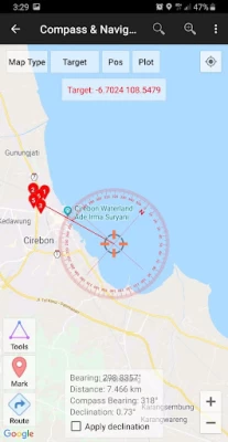
More About UTM Geo Map
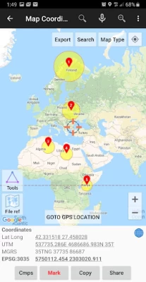
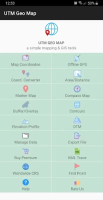
Offline GPS: Used to get coordinates in an offline state (without internet access), your cellphone will function like a Handheld GPS to get Latitude Longitude coordinates, UTM, MGRS, Elevation (ellipsoid), MSL Elevation (EGM96), accuracy, satellite and other useful information. Coordinates data can be stored in an unlimited number inside your databases, given notes / labels, photos or exported into CSV, KML, DXF & GPX formats.
Coord. Converter: To convert coordinates manually from Latitude Longitude to UTM & MGRS and vice versa. It can also be used to convert addresses to coordinates (Geocoding, requires an internet connection). Some conversion is support for batch conversion.
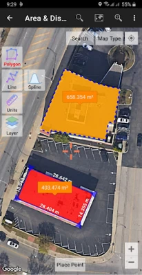
Area/Distance: Used to measure distance and area (support units: m, km, ft, miles, hectare, acre), register lines / polygons, make polygons automatically from measure points, create buffers from lines / polygons, overlay etc.. Line / polygon data can be stored in unlimited number inside your database, displayed on a map, added photos and labels or exported to CSV, KML or DXF format. Equipped with spatial editing algorithms such as Snap Nearest, Delete Object Inside / Outside Polygon, Smoothing (cubic bezier interpolation), Split Polygon By Line, and so on. Can read CSV & KML formats to import or display as reference files.
Marker Map: Similar to the Map Coordinates module but with more complete & complex geometry calculation such as displaying Dynamic / Variable Buffers. In this module geometric analysis such as TIN & Voronoi Diagrams can be made from a combination of point data (markers) as well as lines and polygons (breakline). These geometries can also be exported to KML or DXF files for use on other devices or PC.
Compass Map: Module with a map and compass with magnetic declination, can be used to assist in navigating or measuring the azimuth angle and determining distance & direction.
Buffer/Overlay: Module to perform buffering & overlays (and other GIS operations) with several options including Union, Intersection, Difference and Symmetrical Difference.
Elevation Profile: Used to create simple elevation profiles (cross section / long section) from height data with metric & ft / mile units. This module can also create elevation profiles from multiple points including elevation profile from route (premium).
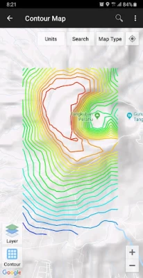
Contours: Module to generate contours based on number of contour lines, desired elevation or contour interval. This is premium module & need internet connection.
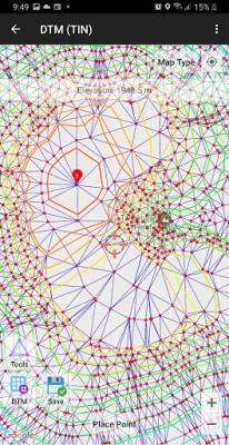
DTM: Digital Terrain Model, module to generate TIN / GRID surface & Contour Lines from elevation data. Calculate Cut And Fill volume, TIN refinement, Grid interpolation and dynamic Elevation Profile.
Some other modules.
Website: https://www.utmgeomap.com
Quick guide (pdf): https://www.utmgeomap.com/utmgeomapquickstart.pdf
YouTube: https://www.youtube.com/channel/UCspxQ5nQiqRD88g_-6GcCqw
Any suggestions are welcome, please submit via email to utmgeomapapp@gmail.com or write a review. Thanks.
Latest Version
4.1.2
August 03, 2024
Y2 Tech
Internet
Android
2,588,940
Free
info.yogantara.utmgeomap
Report a Problem
User Reviews

Virginia Lee Pratt
3 years ago
It's working with a bit of fuss but I have my result in perfect views. I'm not sure of the age of the map satellite view. As elsewhere I can see it years behind in information.. but is doing as much as it needs in general.. good locator..

Mohammedhayatu Lalanda
3 years ago
the app you provide is looks best and it makes me satisfied in my work during road construction but there is little problem that is it can't create elevetion profile for several points instead it works for two point station only. So does if you have any update about to solve such problem, please wellcome.!

isr iissrr
3 years ago
This application is wonderfull , how ever I wish if u could add these features pls 1 -( smart export or sharing ) instead off exporting every polygon or line iv worked on it should export or share the polygon that I want to share 2 - ( more maps ) this application deals only with Google maps while other applications deal with such as alpine deals with ( Bing maps , Google maps , eseri maps , yandix maps , etc... ) 3 - ( 3d models ) showing 3d kml design from skechup or other programs big ❤️

A Google user
6 years ago
Excellent platform to collect GeoData, I am asking about what coordinate system the data based on, is it WGS 1984 or other? I recommend the elevation numbering data, when you export to csv file, be without any text. The (m asl.) unit is better be written in the title of the column, that will help in making any calculation if you open the file in excel as the cell will be treated as number not a text.

Jacob Doucette
1 year ago
Great app! Helps with marking well locations for record keeping. Would really like an option to put marked points in labeled individual folders. Would help to limit a clustered screen as I have over 200 waypoints in a small area. Otherwise this app is great!!
A Google user
5 years ago
Unfortunately, if you are out walking in the woods the trails are very, very hard to see and in sunlight, just forget about it. I really like the interface and all other options, but perhaps a dark mode and more walking trail options are in order. I'll have to uninstall. 😕
A Google user
7 years ago
I am not finding this as useful as I had hoped based on other peoples good reviews. I have tested this app on the top level of our parking garage. The garage is next to our office building. The coordinates are not close enough on target and basically mostly on top of the building and not on top of the garage. In one instance it was a whole block away. I am in Houston, TX, USA, a major city and in a business district.

Johannes Kotze
1 year ago
I bought the app bit still get advertising

Mike Nelson
1 year ago
Satellite images are very out of date at least for my area. The image pulled up was prior to 2017.

Milan Popović
1 year ago
I want some triangles to be formed differently. Is it possible to add breaklines after creating a tin network for surface? Well done for the app

Prafullkumarwaghdole Prafullkumarwaghdole
1 year ago
App is good but improvement in open the kml file, not sutebal keyboard and ad problem. Not draw or create the waypoint, path, line, distance ect.

Justin Hardesty
1 year ago
A simple easy app to blend phone or magellen type gps to hard map coords. I love it

John Kamau
3 years ago
Is it possible to integrate the area/distance measurement tool into the map coordinates section? So that I don't have to go back to the home interface and then navigate to the area/distance section, then zoom in till I find the markers. Just those two would be enough. It would make a world of difference. Otherwise, keep up the good work. The app is stable with frequent updates. One year on and I'm still amazed at the convenience. Worthy of all five stars.

PANKAJ KUMAR SONI
1 year ago
Distance are not show at the line of last point So Distance should be show on last point Present distance is show tha at middle point to ponit

ewuga jamus ulu
1 year ago
I am using a Nokia G50 phone when I open the app particularly the offline icon I can't take pictures.

okuk Pascal
1 year ago
Truely this app has simplified mapping and GIS, Kudos team for inventing this. Thank you

George
1 year ago
1/2 hour on your compass map and uninstalling the app. Needs a complete redesign. Have you ever used it yourself ? I only wanted azimuth and distance between any 2 selected points on a map, the target being the second point, not the first

eric Thompson
4 years ago
Liking this so far. Effectively imported my .kml list of points AND actually let me view them at the same time on the map. (Why this is hard to find in other apps, I dunno.) The variable buffer is quite nice. MY QUESTION: it would be very nice to be able to format that buffer; e.g. change color or have no fill color. Is that possible? A future option?
A Google user
5 years ago
The app has a lot of awesome features and is easier to use than other gps apps I have worked with. However, the second day I used it (after deciding to purchase the premium version) the app crashed over and over and 12 marker points I had saved were deleted. My coworker downloaded the app on his smartphone so that we could finish our field work for the day and within 10 minutes his app was crashing. We ended up using a different app. Pretty disappointed.

W T Whitacre
3 years ago
Great app. Many features. Really like the export function! I'm an engineer and use the app out in the field on an irregular basis to verify field conditions at project sites. The problem with the app is many features require unlocking with a 3 mo subscription with no yearly or permanent option. I use the app at field sites that a lot of times Don't Have Cell Service ! No Way to Buy or update a subscription at those sites if you need to use one that has expired ! Can't add Needed things then.


