US Topo Maps
December 18, 2024More About US Topo Maps
turn your Andoid Phone/Tablet into an outdoor GPS for offline trips into the backcountry.
Add easily maps from other sources (GeoPDF, GeoTiff, Online Map Services like WMS, ...)
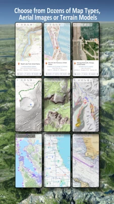
Available basemap layers for USA:
• USGS National Map Topo
• USGS National Map Imagery Topo
• USGS National Map Imagery
• USGS NAIP HiRes Imagery
• USGS Topo traditional DRGs: Seamless coverage of topo maps of the USA at Scales 1:250.000, 1:100.000, 1:63.000 and 1:24.000/25.000
• FSTopo Forest Maps
• NOAA Nautical RNC Charts
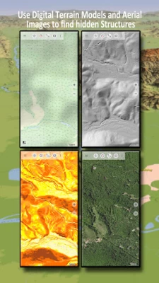
• National Elevation Maps (Hillshade, Slope Map, Aspect Map)
Worldwide basemap layers:
• OpenStreetMaps (5 different map layouts), also downloadable in space saving vectorformat
• Google Maps (Satellite images, Road- and Terrain-Map)
• Bing Maps (Satellite images, Road-Map)
• Earth At Night
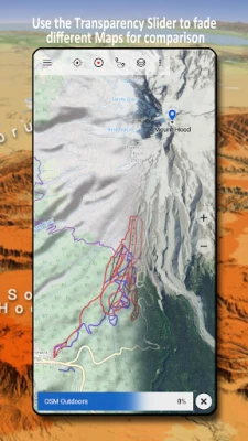
Configure a basemap layer as an overlay and utilize a transparency fader to seamlessly compare maps with each other.
Add maps from other sources:
• Import raster maps in GeoPDF, GeoTiff, MBTiles or Ozi (Oziexplorer OZF2 & OZF3)
• Add web mapping services as WMS or WMTS/Tileserver
• Import OpenStreetMaps in Vectorformat, eg complete USA for just some GBs
Available US map Overlays - add additional information to any other base map:
• Public Land Ownership (PAD-US 3)
• National Hydrographic Dataset
• Motor Vehicle Use Map (USDA)
• Elevation Contourlines
• 4WD Trails
• Trails
• Roads, Railroads, Airports
Available worldwide overlays:
• Hillshading overlay
• 20m Contourlines
• OpenSeaMap
There is no perfect map. Toggle between the different map layers or use the compare maps feature to find the most interesting route. Especially the old traditional DRGs contain many small pathes or other features that are missing on modern maps.
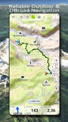
Main features for outdoor-navigation:
• Download map data for OFFLINE USAGE
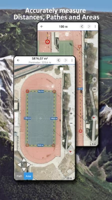
• Measure pathes and aereas
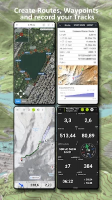
• Create and edit Waypoints
• GoTo-Waypoint-Navigation
• Create and edit Routes
• Route-Navigation (Point-to-Point Navigation)
• Track Recording (with speed, elevation and accuracy profile)
• Tripmaster with fields for odometer, average speed, bearing, elevation, etc.
• GPX/KML/KMZ Import/Export
• Search (placenames, POIs, streets)
• Get elevation and distance
• Customizable datafields in Map View and Tripmaster (e.g. Speed, Distance, Compass, ...)
• Share Waypoints, Tracks or Routes (via eMail, Dropbox, WhatsApp, ..)
• Use coordinates in WGS84, UTM or MGRS/USNG (Military Grid/ US National Grid),
• Track Replay
• and many more ...
Use this navigation app for outdoor activities like hiking, biking, camping, climbing, riding, skiing, canoeing, hunting, snowmobile tours, offroad 4WD tours or search&rescue (SAR).
Add custom waypoints in longitude/latitude, UTM or MGRS/USNG format with WGS84 datum.
Import/Export/Share GPS-Waypoints/Tracks/Routes in GPX or Google Earth KML/KMZ format.
See animated NEXRAD rain radar to make accurate predictions when raining will start/stop
Please send questions, comments and feature requests to support@atlogis.com
Latest Version
7.5.0
December 18, 2024
ATLOGIS Geoinformatics GmbH & Co. KG
Internet
Android
1,828,709
Free
com.atlogis.northamerica.free
Report a Problem
User Reviews
A Google user
6 years ago
I like most of what it's capable of - I like the usgs map features; use this app for scouting activities. I find it very complicated to use ... a lot of that is because of terminology used in titles. Lately the app has been ending tracks without me pressing the "end" button - perhaps loosing connection to a satellite?
Shane Shepherd
3 years ago
Overall, not bad. But, if you want to download a detailed area of your state for when you have no cell signal - good luck! I've been trying to download a segment of my state for five days! First, there is no "resume" if the download stops. There is "restart" and the app tries to download everything again. It validates some tiles - but, the validation takes so long that my phone will pause so to inactivity before it finishes validating! I can never get more than 75% of level 16.
A Google user
5 years ago
One big problem This is an excellent app for displaying a wide variety of different maps. One serious negative is that it won't let me zoom in enough to read the labels. I can momentarily pinch zoom in, but as soon as I let go it snaps back out so i can't read it again. Why? Seems like an arbitrary restriction that greatly reduces the usefulness of the program.
Ccore
4 years ago
I'm still really new to navigating the wilds, but this app is easy to understand with the experience I do have. I was able to navigate a brand new trail I found using this. Definitely worthwhile to have. Still, its more of just a map than anything, I couldn't remember what direction I was going in so I had to turn back at a certain point. Wouldn't hurt to carry a real compass with you when using this.
K Halladay
2 years ago
This is a fantastically useful app. It's generally easy to use, reliable, and provides a wide selection of base layers and overlays. Route tracking is accurate, and even while active, isn't too bad a drain on battery life. I still carry a backup paper map in more remote areas, but I'm very comfortable using this app as a primary. Really I'd like to give this app 4.5, not 4 stars, the half-star for the confusing process of importing data from external sources. That said, it's worth every penny.
Herb Schroeder
3 years ago
I'm upgrading this to 5 stars. I finally found an Android setting under the app's battery usage that needs to be set to Unlimited. With that change, the tracking function works as it should. [Original post: Would be 5 stars if I could get the tracking function to work without having to keep the display on at all times. Turning off the display stops recording the track, which makes it unusable for anything longer than a very short walk. I've given the app every permission I can find and turned off the device's battery-saving features, but have not been able to find any way to solve this issue.]
Phoenix NightOwl, Jr.
3 years ago
This app must've been updated, since the 1st time I tried to use it, it told me I didn't have enough memory, but now, that's no longer an issue, & it loads & works quite well. (If I wasn't physically disabled, I'd be using it a lot more, even with the presently insane fuel costs.) (If I can ever get my spine rebuilt properly, or find a way around the disability, I'd be a "full-time" RV'er, & have this app in the "spare" phone I keep on my dashboard.) Good job on the updating!
John Reed
1 year ago
I had the premium version of this several years ago. I have recently installed it again to find out that I no longer have that. If there is a reason behind that or maybe got lost within the several years of updates that were missed. Then that is my own fault. I'd rate it higher if it didn't want me to pay for the premium service again. Other than that it is a very useful application especially for military or any other kind of land navigation scenarios that you may use it for.
Ron Eaglin
5 years ago
I have the professional version (upgrade from free). This is a really easy map application but it is meant for people who understand maps and specifically USGS topo maps. It also appears that the maps used are relatively (remember these are old maps) up to date. So if you want good outdoor maps and basic GPS functionality (waypoints, tracks, positioning) - this is the best. What it does lack is collaborative features that some of the services offer (at a much higher cost) - such as recent GPSs trails and information about those trails (trailheads, features, shared waypoints, etc...) The newer off-line map feature has proven tremendously useful as many locations have nearly zero coverage. Recommendation: Install this, if you like it and use it - upgrade to pro for more extensive features.
Daniel Fagerlie
1 year ago
Amazing app for years! For those who want a stable offline or online map client for running, hiking, walk etc that can record tracks, this is perfect! For more advanced users, you can export the tracks (automatic or manual). I use Syncthing to automatically copy the tracks over to my laptop and server so I can do cool things like open up my recordings on QGIS. I'm thinking I should now contribute to OpenStreetMaps by uploading my trail recordings. Highly recommend purchasing.
Your Mother
4 years ago
Unbelievable map resource...and im only using the free app. Will definetly buy the pro version when i get a new phone. In free you get crazy maps, overlays, weather, etc plus route tracking, so many GPS functions as well. If you spend time in the woods and want more than google/apple maps for camping, hunting/fishing, trail work, hiking etc, then you need this.
Terrible619
3 years ago
I purchased the full version and have been using this app for a few years now and am overall happy with its features. It is simple. It loads and operates quickly. I can save tracks. I can import gpx files from friends. It is mainly used in offline mode using previously downloaded ESRI aerial or topo maps which I find the most useful. Downsides, you Aren't allowed to download Bing or Google maps to your device but can use them when in cell range. It lacks historical satellite imagery.
Senor Mule
2 years ago
I use a myriad of maps on a daily basis for work and recreation. Been using this since it first came out, tried many other map sets and this is still the best by far. Bought a new phone and had issues reinstalling the pro version, developer was extremely helpful in a quick resolution, and very conscientious regarding help in using it in the past. I have recommended this app to about 10 people, who like me, use it in work, and they are very happy with it as well.
A Google user
6 years ago
By far the very best topo map app I have ever used, and that isnt even the tip of the iceberg as far as how versatile and incredibly useful this app can be. In so many different ways. A total hidden gem for hiking and wilderness navigation, (or waterways) for hiking or work, etc; this is the only app you will need for navigation or travel. I never even leave reviews, but this is that good of an app, its now a crucial tool ill be using for all my hikes, huge appreciation for the makers of this.
Lee Kern
1 year ago
Overall, I like the app. The only reason I downloaded it was to use the Hillshade layer(LIDAR). When using this layer, the map fails to download completely, and the blocks that do download take minutes to do so and sometimes disappear. I've tried while connected to a very strong internet connection as well on 5g and 4g. The topo and satellite maps load like they should. Is this a bug? Can this be fixed with a setting?
A Google user
2 years ago
Absolutely love this app. Would probably get pro version if it cost a little less. The location and track are very accurate and when using satellite map layer it is an amazing tool. In the top 3 of my favorite apps. Edit 9/11/23 OMG this has gone right to hell! Most obnoxious full screen ads ever! Looking for new app pronto
Asher Merrill
3 years ago
Works phenomenally. Very pleased. After using FrogSpark's MyTrails for years, it seems to have finally broken on Android 11. US Topo Maps replaces all of its functionality and adds nicer, more complete map sources, a radically more up-to-date, intuitive, and helpful UI, and many features that simply didn't exist in MyTrails. I don't typically like paying for apps, but given how much I depend on digital atlases while backpacking, hiking, skiing and whatever, this was well worth it. Thanks guys, I love your work!
Lou Novak
1 year ago
the program works but the map images arent sharp and are hard to see on a phone screen. it has a lot of potential to be a close rival to OnX but as it is, it can only tell you where you are currently in relation to surrounding landmarks that are shown on the map. as a route planning tool it is worthless until the zoom graphics get enhanced. if one has patience and a general understanding of the area they are in, it may help to become un-lost, or less confused as to which direction to go..
Barbara Fletcher
1 year ago
I've been a happy user of US Topo Maps since 2016 and have just upgraded to the latest version. It has everything that I use/need/want at an incredible price. Some of my favorite features are the GPX imports, easy route creation, lots of information about routes (for example elevation profiles) not to mention the ability to add maps such as Geo PDFs and Geotiffs. The developers are accesible and responsive. I couldn't be happier! Thanks Atlogis!
William Murphy
11 months ago
It is one of the best apps for navagation I have ever used, and I use it a lot. The guys who put this together knew what they were doing, a great job! I use it for hiking and driving in the remote areas of Utah, Arizona and Nevada. XC Skiing, Mountain Biking and Hiking I download maps for areas that I don't have cell service in. Works great!
