
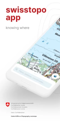
swisstopo
September 13, 2024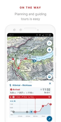
More About swisstopo
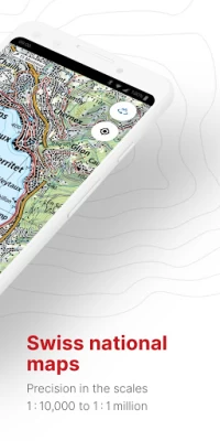
- all scales from 1:10 000 to 1:1 million
- current aerial image and historical maps
- official hiking, mountain hiking and alpine hiking trails
- closures of hiking trails
- snowshoe and ski routes
- SwitzerlandMobility routes
- public transport stops
ON THE ROAD
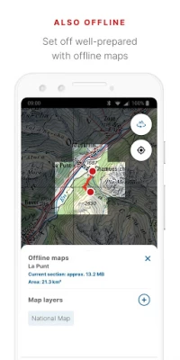
- free offline maps (1:25 000 to 1:1 million)
- draw, record, import and share your own tours
- set tour type (hiking, cycling, mountain biking) and personal pace
- tour guide (arrival time, remaining distance)
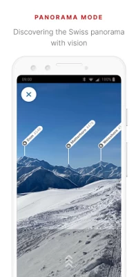
- panorama mode (labelled panorama, view tour in "3D")
- save markers, add notes, share
TOOLS such as measure, compare and search (for geographical names, addresses or coordinates)
Report changes to maps and geodata
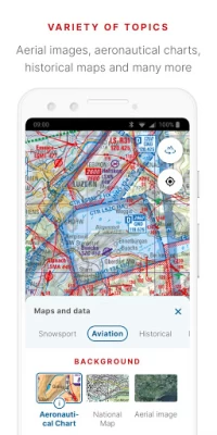
AVIATION
- aeronautical charts, obstacles, airspaces
- landing sites
- restrictions for drones and model aircrafts
Do you have a question? Then write to us:
support-cd@swisstopo.ch
Latest Version
1.16.2
September 13, 2024
Federal Office of Topography swisstopo
Internet
Android
831,237
Free
ch.admin.swisstopo
Report a Problem
User Reviews

Nicolas Odermatt
3 years ago
The tour drawing crashes repeatedly on my Google Pixel 3. I reinstalled the app and restarted the phone and tried again but still cant edit a tour for more than 30 seconds. This is one of the most prominent features so it should be rock solid. I'm happy to submit a better rating once that has been improved.

Reto Hermann
5 years ago
Beware, the offline functionality of preloaded maps does not work reliably in situations where there is no internet connectivity. So, always take along a printed backup if you're absolutely dependent on map material. I personally deem it irresponsible to advertize offline functionality given the erratic behavior of the app in its present state, because it may put people that rely on it in truly dangerous situations.

Noam nleanba
4 years ago
It recently started having quite the problems loading the map, showing an icon indicating connection problems even in WiFi. The Route-Feature is very cool EDIT: I don't think you understood my problem: it's not loading the map, even when I'm connected to my (otherwise very fast) WLAN! It stays blank for ages (10m+) and shows the small offline icon in the top left corner

Marco Müller
3 years ago
Looks sleek&shiny, but this sleekness comes with the price that you can't zoom out with only one hand... Kind of unpractical if you're standing somewhere in the Swiss Alps and it's -10°C. Honestly, the app looks great, but it's just annoying to use. Menus are convoluted, everything is different than in any other map app. Somebody tried to reinvent the wheel, the result is frustrating. The maps are great though, of course.

Sébastien Brennion
5 years ago
Offline map are really working randomly, as soon as I want a bigger map, it's seems to freeze at some point, as the download status isn't displayed in percentage, it's difficult to know, but I tried several times and it's stays on more than 1000 min for days. I'm really missing the ability to pause or continue the download from offline maps. I'm also unable to display the scale , what is very important to me. I'm also not sure that precise background maps 1/10000 are available. Needs improvement

Marek Basler
5 years ago
Some major functions available in the old app missing here. For example, no SwitzerlandMobility POIs, such as Places of interest. No scale in this app. You could quickly move the map in the old app and see how far the center is from your current position, or learn how high is that place. Rendering was faster in the old map. Ability to use route planing is great! It would be nice if one could add new waypoints easier (e.g. dragging current route) and set hiking trails as priority (avoid roads).

Steve Mullerworth
2 years ago
Great app for searching for hiking routes and following them. It provides altitude profiles and estimated walk times which update as you progress. Care is required as some trails we followed were almost non-existent. Usefully, it shows up trail closures. Currently, however, it crashes a lot - probably 15 times on a walk today. It does restart quickly so crashes were not hugely disruptive.

Daniel Meyer
2 years ago
I have used this app for quite some time like it a lot! One factor it sets it above competing apps is, that you always see the time left on your planned route which gets updated as you progress. But: In the last two months, the app crashes all the time when I have a route selected to follow it. It might be an issue related to zooming and relying on offline maps. I wasn't able to pinpoint it. I use version 1.11.0 on a Pixel 7 pro with Android 13.

Julien Falco
3 years ago
Great app, but it's really struggling to download maps with a weaker network coverage. Update 24.10.2023: it's not that. It really wasn't able to download maps, even with good coverage. What I did instead: I removed and re-installed the app, and now it works. There must have been corrupted memory files or smth. It would be worth investigating the logs on your end. Pixel 5 phone. Thanks.

Raphael
5 years ago
Best topographical maps of Switzerland. However, the map takes very long to load and offline maps often fail to load completely. Besides, it is missing a scale and road names, and the routing function is very awkward to use and doesn't work offline. Unfortunately, the app also requires Google location service.

ch al
5 years ago
The map itself is okay, but creating tours doesnt really work and offline maps are overprized (chf 38/year), thus I'll not use the app until there are major improvements. Alternatives, such as bergfex (~4/year) or mapy.cz (free) are miles ahead. -drag and drop (to change waypoints) only works on rare occasions -sometimes, setting new waypoints doesnt work either. -I cannot delete waypoints for some reason Additionally, tours can only be created for hiking but not for cycling or other sports.

Andy Kiser
5 years ago
The basic concept of the app is fantastic. Route editing is much easier than in the previous SwissMap, but still there is no way to insert waypoints into an existing route. Route recording is very unstable: I couldn't manage to record more than 30 minutes before the app crashed and lost all the recorded data.

Daniel K. Schneider
5 years ago
The app icluded superb maps, must have for mountain hiking. 2 stars only because it cannot be used as stand alone hiking app and there are offline problems. The list of missing simple features is long. E.g. distance measuring (worked in the old app), display of critical data like altitude and position, scale of the zoom and a meter, direction, import of gpx files, .. Problems: In an area without network the tiles just disappeared, can be dangerous! Defining a hiking path is difficult, eg insert.

Cédric Dufour
5 years ago
Interface is definitely more friendly than its predecessor; however: it is not obvious one may scroll available maps themes horizontally + when clicking on the "my location" icon, aviation maps are zoomed to the point of switching to the topo map (which is a real annoyance) + I miss the red box delimiting offline content + I'd love an option to disable (involuntarily) turning the map away from the north. The Tour (and auto-routing) feature is great!

Michael Walter (McEnding98)
1 year ago
Best navigation map that exists. Free and the topology department outdid themselves with this.

Nautilus (CptNautilus)
1 year ago
I have been using this apps for years now. It used to be the best map app for Switzerland. I was using to prepare my trips at home (I have the paid version) and on the field. Alas, since the latest update, it makes my phone overheat to the point of burning my fingers and deplete the battery so fast that it has become useless in the field, where I can't recharge my battery and it has to last for the whole day. Samsung Galaxy S10, Android 10

Bohdi Politic
1 year ago
UX is weird and un-intuitive. Has no backup function. I just lost all my data.

Leon Horlings
1 year ago
The time estimes are incredibly accurate. It's also really nice to have a good overview into the elevation gain/loss.

l p
1 year ago
This is the best hiking app for Switzerland. There are more hiking trails than in alltrails and komoot, route planning is extremely easy: it snaps to path, you can drag the route around, it displays all the usual statistics. Downloaded maps are available offline, you can import the hike into your usual hiking app if you want to keep your hikes history in one place. And it's free.

Igor Schneider
1 year ago
Recently the app became somewhat unstable, crashes from time to time when navigating and crashes almost every single time when you want to delete a saved tour. If this issue would be fixed it's definitely 5 stars again. Great App for hiking! We mainly use SwissTopo for navigation in the mountains.


