

Mapy.cz: maps & navigation
July 26, 2024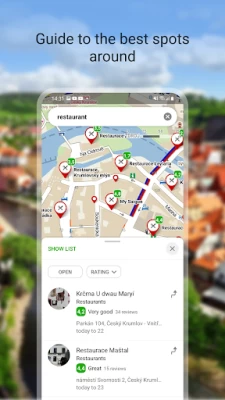
More About Mapy.cz: maps & navigation
- cross-country skiing and ski-alpine trails
- unique “travel tips” feature plans a trip through the most interesting places in the area
- route elevation profile
- 5-day weather, temperature, wind and precipitation forecasts for any location on earth
BROWSE THE TOURIST MAP OF THE WHOLE WORLD
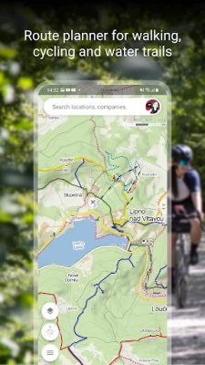
- hiking trails, bike trails, singletracks and single trails
- marking of roads, mixed cycle paths, unpaved paths and footpaths
- hillshade anywhere in the world, marking of ferrata and their difficulty
- educational trails, pedestrian closures, national park zones
- routes for wheelchair users
SWITCH TO OTHER MAP LAYERS
- aerial map of the world
- panoramic images of Czech streets and 3D view
- winter maps with up-to-date cross-country ski trails and ski resorts
- traffic map with current traffic, closures and parking zones in the Czech Republic
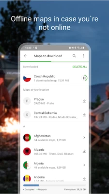
DOWNLOAD OFFLINE MAPS
- offline tourist map of the whole world with hiking and cycling trails
- offline voice navigation for drivers, cyclists and pedestrians
- offline winter maps of the Czech Republic with cross-country skiing trails and ski resorts
- individual regions for download and navigation
- search for places and plan routes around the world even without a signal
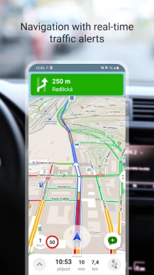
FREE NAVIGATION FOR DRIVERS, CYCLISTS AND PEDESTRIANS
- clear instructions on which lane to get into
- highlighting of roundabout exits
- ability to avoid toll lanes
- dark mode in the navigation
- sharing arrival time, route and current location via SMS, email or chat
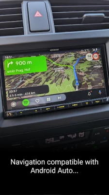
- view navigation onto the large on-board display via Android Auto
- view navigation onto the large on-board display via Apple Car Play
- speeding alerts and speed cameras for the Czech Republic
- important notifications from other drivers about accidents, police patrols, roadblocks, road closures and roadworks in the Czech Republic
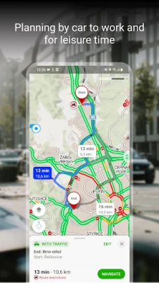
- the latest traffic situation in the Czech Republic with an overview of traffic jams and alternative routes
- warnings on sections of frequent traffic accidents on Czech roads, sections without winter maintenance
SAVE TO MY MAPS
- save places, routes, photos and activities in clear folders
- track activities with Tracker for walking, cycling, running, cross-country skiing and hiking
- GPX file upload, GPX import and export
- synchronization of planned routes across devices
CHOOSE BY REVIEWS OF PLACES, RESTAURANTS AND SERVICES
- up-to-date user photos of what the place looks like
- users' experiences with food, service, ambience and price
- search by rating level and highlight top-rated establishments
RECOMMENDATIONS AND TIPS:
- you will need an internet connection to download the map
- to make the app work properly, turn on location services in your phone settings
- for questions or troubleshooting, use the form in the app settings
- using the app in the background with GPS running can reduce battery life
- join our user community at www.facebook.com/Mapy.cz/ to share your experience with the app, follow the latest news or suggest new features
Latest Version
9.51.0
July 26, 2024
Seznam.cz, a.s.
Internet
Android
9,044,530
Free
cz.seznam.mapy
Report a Problem
User Reviews

Peter
1 year ago
The best maps out there, and they are free. I've had a few hiccups whilst out cycling. The voice navigation sometimes tells me to take the first right. When I do,it asks me to turn back. I will one day figure out why it does that, and post it here. In the meantime it's still an exceedingly good application.

dominic learwood
1 year ago
This app might be good for trails and bikes but im not loving the car experience. Reviews suggested there was a toll calculator but this does not exist. For car navigation it's not really that different from Google or Waze. Sometimes when planning ahead I delete my location but when you hit navigate it comes back on. I might give it a try still, because it might be useful for those other things but for driving I might just stick to Waze.

Petr Janousek
1 year ago
The best map application. Using in car and hiking. I am just missing the volume settings when playing notification from phone speaker while connected to bluetooth

Jonas Westin
1 year ago
Good maps and very good and dependable offline functionality. Maps are NOT vetted and you should always get a second source or verify any routes for alpine routes or routes in unknown terrain (sometimes eg ridge climbs are included as hiking paths without any hint that a full trad rack or via ferrata set is needed). Would be cool to be able to pull a gpx track straight into the app without having to use the web sign-in.

Bogdan-Marius P.
1 year ago
As far as I'm concerned, the most complex and detailed graphics and spot on trails. It never failed me, even at difficult times finding water the map helped a lot , used it in Europe and all the Andes intensely.... P.s. better than maps me or whatever other free map, really worth it a donation. Thank you guys, you've been my eyes for many years now :)

Adrian M
1 year ago
I rate it 3* because of the potential the app has. The maps are decent, the offline works, I like most the altitude and the weather factor in route estimation. Lots of good things about the app but the registration process is terrible and I gave up registering. They require an SMS to be sent to an international number, which is blocked by many North American carriers. The app developers either don't know this or they don't care, otherwise they would remove the SMS registration immediately.

Roman
1 year ago
Nice feature to be able to save planned trips. Negative for the app is that the time calculations does not take your pace into account. For every three hours of walking i usually cut one hour from the time, so if you walk faster than 3km/h you can not relly on time calculation.

Stanisław Zagórowski
1 year ago
Great app, accurate trails, incredible offline support, and an often-omitted feature: you can turn off rotating the map with two fingers, which makes it great to use in cold weather, rain or in gloves.

Nicolai Cauchy
1 year ago
Inaccurate for trails in my area (Valromey, France) and doesn't consider comments/updates - I've alerted Mappy several times to trails no longer in existence or impossible to pass (due to privatization, logging destruction, etc...) with supporting photos, but Mappy doesn't update their maps. UNRELIABLE, BEWARE!

Mikael Johansson
1 year ago
Great for offline navigation on hikes. Their website is phenomenal for planning hikes beforehand on a laptop, it has a 3D mode like Google Earth which can plot routes both on hiking maps or aerial maps. This is my go to site/app for both trail planning and navigating. Just create an account and the routes will sync to your phone, can even share and collaborate on routes.

Martin Swingler
2 years ago
Great app in many respects. Even works better in England than Google Maps. English navigation is a downside. Czech placename pronunciation is completely unfathomable; it makes no sense whatsoever. Why not pronounce placenames as they should be pronounced? I speak Czech and live in Czechia. I choose to use the English version, as I prefer the app’s menu to be in English. The navigation narrator’s English is incorrect in several respects. I’d send detailed feedback if I knew where to send it.

Steven Lefavour
3 years ago
I think I love this app So far, the map collection is really good, though I just have used it at home for trip planning and virtual touring. ¡This app has an SOS feature! You can use it to call for aid; it seems to pull up the local telephone info for your location, gives a precise map coordinate and allows you select from a list of first aid responses. Výborně!

Jakub Calouseque
1 year ago
So far most user friendly app - legible, fast, intuitive, practical - as compared to laptop, the best feature is however customizable plotting of loop tracks . It will create loop tracks based on your input parameters...splendid if you do not know the area.As compared to backcountry guru maps, and viewranger If you travel worldwide this is the best even with the limited topo capabilities, e.g. slope available on line only. Definitely great back up for usually unreliable gps plotting apps. Still

Jim Hewett
2 years ago
Simple, guick, great maps, works when the net does not. Good to have in your pocket. Would be perfect if waypoints and tracks were saved to the device rather than someone's cloud. But hey, its free. It has replaced all my other gps apps (and there have been several) because it is simple and works well.

Nitsan Bar
2 years ago
A really great mapping app, best I've found. However, the integration with Seznam is quite bad. They make you register (for saving paths) even though nobody wants their account. They try to get your information, e.g. phone number, year of birth. The reset password mechanism is broken. Opening a second account with the same number is broken. All in all, a world class app integrated with a bad provider.

Hayes Weggeman
3 years ago
I like the app. It works well. I did have an issue recently while walking where it seemed to send me 180 deg from where I should have been going. After asking someone for directions I corrected my path and after walking a while the app seemed to correct and then took me to the correct location. You download your maps before hand and then you don't need any wifi nor cellular connection after that, just have your phone gps enabled and it works good.

Robert Clark
2 years ago
This has been my go to map for hiking, bicycling, and motorcycling for about 6 years now. And it's free to use with offline downloads, and you can record tracks. I've used it all over tur world, even has tracks in remote places like Tajikistan and Afghanistan. I'm so greatful for the friend that shared it with me. I'm sure there are subscription maps with more detail, but mapy has always been good enough for me.

Petr Majer
4 years ago
I don't use mapy.cz for driving very much, but for hiking or other outdoor activity it is by far the best map app I've ever used. And I've tried multiple. Downloading offline maps is very easy and setting up routes and navigation is intuitive. It's a Czech app but has trails for any country in the world. Have used it in Scotland, Armenia, USA, Bulgaria and Switzerland and everywhere it's very useful

First Last
1 year ago
Track recorder is practically useless- to save any recorded track the app requires data/Internet access AND some online account (like anyone actually needs yet another account). And Internet access isn't something readily available in the boonies- while hiking in a forest or NP. I wonder if the developers ever get out of the office and experience the actual outdoors to have come up with this "brilliant" solution. Ever heard of OFFLINE functionality, especially for a mapping app of all things !

SL “S”
1 year ago
Good and it's free! I will give 5 stars if have all the gravel bike trails, bike lanes, and more options of how to custom bike routes such as easy ride and avoid busy traffic roads. Plus need to have more options of choosing different types of bicycle such as gravel, touring, etc. It will be really nice and to use when planning routes just be able to draw right on the road not Markers. Please add this features in future updates thank you! Kudos to the developers, you are awesome! Thank you!👍🏼


