
GIS Surveyor - Land Survey and
October 13, 2025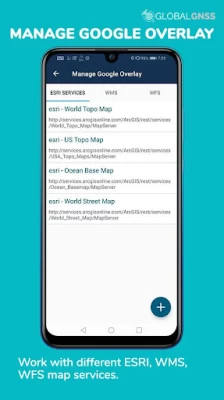
More About GIS Surveyor - Land Survey and
GIS Surveyor is a GIS application meant for GIS survey, GIS Data handling, data collection, analysis, and planning before execution of a project. It allows professional surveyors with an opportunity to collect more accurate survey data in a stipulated time frame. This application is also a GIS remote sensing application that can be used for GIS Mapping.
GIS Surveyor is a GPS/GNSS based survey application that uses GPS data collection. It will be used for various types of environmental surveys and field surveys while also enabling the GIS data collection to be faster and efficient.
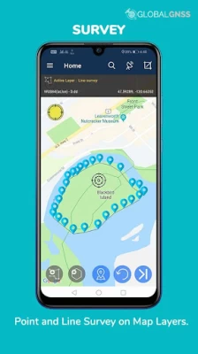
This application can be used for Field Survey,Land Survey,and other surveys which includes field data collection including internal GPS or external GPS.
-Top GIS Survey Application features:
- GIS data collector
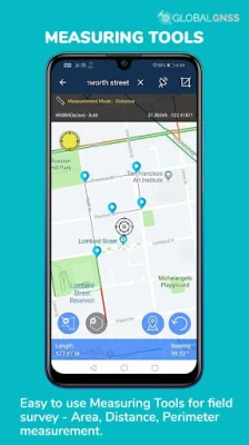
- Calculate the area and distance.
- GPS land area calculator
- Attributes can be imported from any other project or device.
- Survey using images for any location is available, with multiple export options.
- One set of attributes can be used across multiple surveys.
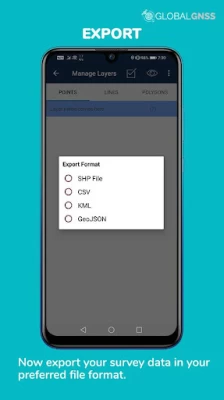
- Various Export file formats for GIS data are CSV, KML, and GeoJSON.
- Post process of data can be performed with software like ArcGIS, ArcGIS online or qGIS.
- With external Bluetooth GPS/GNSS device connected, NTRIP/RTK data can be utilised for accuracy.
- Survey on online gis maps, and GIS offline maps(supports mbtiles)
- WMS and WFS Surveyor tiled maps are supported, load topographic and orthophoto maps, geological surveys, cadastral information.
- Currently 4 methods of data collections are supported, GPS / GNSS location, map cursor location,GIS Tracker, point projection using angle and distance.
-Mapit GIS survey on multiple kinds of GIS maps.
- Direct export to Dropbox,Google Drive, FTP location.
- Import point, line and polygon layer in CSV, KML or geojson file.
- Possibility to view multiple layers including points, lines and polygons at the same time.
- Possibility to group the data into survey layers - each survey layer may have a default set of attributes.
- Create new polygon or line features and measure details like area, length and perimeter.
- Backup management.
- Export in .SHP format .
- Export in GPX format..
- Works with GEOID Model to provide elevation for a point.
- Recieve Mock Location from 3rd party application.
- Coordinate System Geoid EGM96
Industries that our survey application caters to:
- Forestry and Timber inventories.
- Residential Land, Commercial Land, and Government Land.
- GPS surveying and GNSS survey.
- Land Survey.
- Agricultural and Farm Survey.
- Field Surveys.
- Environmental Systems.
- Highway Road surveys.
Supports Android OS 4.4 and above
This application is made ads-free and hence it will increase your productivity. If you have any problems in installing or downloading or if you face any kind of issue with the application functionalities kindly raise a ticket at: http://globalgnss.com/support/
Visit us at www.globalgnss.com.
Latest Version
2.10
October 13, 2025
PoloSoftech
Internet
Android
259,971
Free
com.globalgnss.gissurveyor
Report a Problem
User Reviews

TheWindstalker
1 year ago
It has complete access to your device to copy, share, delete, etc, any and all data... Should be illegal...

Tim Carlson
1 year ago
Doesn't work at all. Stuck in the ocean and can't move or do anything.

Sharkus Velarde
1 year ago
Didn't work for me, couldn't find my location and then would crash.

Julio Tolento
3 years ago
You call to get a estimate and they never answered or they tell you that they don't work in the area where you need it.

HDVARNEY NZ
3 years ago
Very good app. Be even better to set the satellite measurements down bellow 1m

A Google user
5 years ago
3 days use what a joke. Then buy! Didn't use as I am not a pro and need time to figure out. They sell the email address for income most likely.

caesar literatus
5 years ago
It always says failure after i enter my email address. It wont start.

Hannah Olson
4 years ago
Didn't work period. Didn't save coordinates, didnt record distance, nothing. Worthless waste of time.

mark buckmire
1 year ago
For some reason this app could not get .you location and had me in the middle of the sea on west coast of the African continent.

Tommy Bowden
5 years ago
How can this application be useful to a licensed surveyor without the ability to manually enter points (from say a theodolite - total station). Without it, this app is a toy.
A Google user
5 years ago
GIS is great collector data. Clean interface and easy to use. I really like this app it is very useful.

Alan Langridge
4 years ago
It is impossible to import a kml file. It just keeps telling me the kml file is not in the import folder but it is impossible to find the import folder.....
A Google user
6 years ago
Clean, simple interface makes this app incredibly useful and easy to use. Love it for making simple maps and measuring area and perimeters! Glad to have it on my phone!

Deborah Samovar
4 years ago
Has lots of features but it really requires time to figure out how to use them all and just do something really quick that's impossible so I guess it's okay but for my purposes not okay
A Google user
6 years ago
It is nice though it is in beta version yet it is useful. It would be more convenient if I can add layers or themes from external files like .shp files and other compatible formats.

Nathaniel Prah
6 months ago
The app can run but the GPS doesn't work even though I have given it permission and the GPS is on. It's is asking for file permission but I couldn't give it the permission.

Sun Grown
5 years ago
No ability to manually enter a point? I'm at a loss how anyone finds this application useful. There is no option to manually enter GPS measured points to define areas. The only method I see is moving the map around with your finger and creating a waypoint under the cursor. Seriously?
A Google user
5 years ago
The app is a great survey tool. With a lot of features. I will be using this app along with a gnss reciever to map agricultural underground drainage lines. When I first tried the app it wasn't clear how to use it, so i down loaded the user guide. The user guide is a must for a beginning surveyor to get started and it is still going to take some time figure it out. A nice feature, would be to list the call points and the coordinates on the page where you can see how many call points you have.

Tim Blossom
1 year ago
This may very well be a great app, but unless you have a ton of time to figure it out, you will be frustrated. After installing and opening the app, you click on user guide to be directed to an ad. I'm not sure what happens after the ad, but I find it ridiculous that I have to give my personal information to an ad to see the user guide. I removed it and will seek another solution.

Sarah Brunetto
4 months ago
I installed the app and then it wanted me to give it permission to read, change, or delete any files on my device even if they had no relation to the app. This is a very unsafe app permission. Im not sure what possible reason it could have for wanting this permission. I would definitely not download and use this!!


