Geo Tracker - GPS tracker
June 12, 2024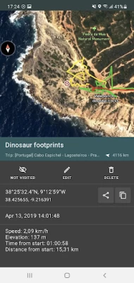
More About Geo Tracker - GPS tracker
Geo Tracker can help:
• Making the way back in an unfamiliar area without getting lost;
• Sharing your route with friends;
• Using someone else's route from GPX, KML or KMZ file;
• Marking important or interesting points on your way;
• Locating a point on the map, if you know its coordinates;
• Showing off colorful screenshots of your accomplishments on social networks.
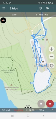
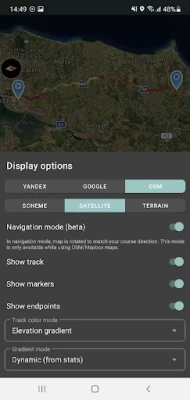
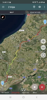
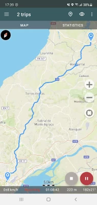
You can view the tracks and the surrounding area in the application using a scheme from OSM or Google, as well as satellite images from Google or Mapbox - this way you will always have the most detailed map of the area anywhere worldwide. The map areas you view are saved to your phone and remain available offline for a while (this works best for OSM maps and Mapbox's satellite images). To record and calculate track statistics only a GPS signal is needed - the Internet is only required to download map images.
While driving, you can turn on the navigation mode, in which the map automatically rotates in the direction of travel, which greatly simplifies navigation.
The application can record tracks while being in the background (on many devices, this requires additional configuration in the system - be careful! The instructions for these settings are available in the application). Power consumption in background mode is greatly optimized - on average, the phone's charge is enough for a whole day of recording. There's also an economy mode - you can turn it on in the app settings.
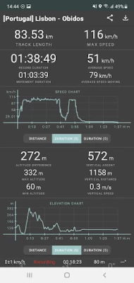
Geo Tracker calculates the following statistics:
• Distance traveled and recording time;
• Max and average speed on the track;
• Time and average speed in motion;
• Min and max altitude on the track, altitude difference;
• Vertical distance, ascent and speed;
• Min, max, and average slope.
Also, there are detailed charts of speed and elevation data available.
Recorded tracks can be stored as GPX, KML, and KMZ files, so they can be used in other well-known applications like Google Earth or Ozi Explorer. Tracks are stored locally on your device and are not transferred to any servers.
The app does not make money from ads or your personal data. To support the development of the project, a voluntary donation can be made in the application.
Useful tips & tricks to solve common GPS issues with your smartphone:
• If you start the tracking please wait a bit until the GPS signal is found.
• Restart your smartphone and make sure that you have a "clear view" of the sky before you start (no disturbing objects like high buildings, forests, etc.).
• The reception conditions are permanently changing because they are influenced by the following factors: weather, season, positioning of satellites, areas with bad GPS coverage, high buildings, forests, etc.).
• Go to phone settings, choose "Location" and activate it.
• Go to phone settings, choose "Date & time" and activate the following options: "Automatic date & time" and "Automatic time zone". It may occur that it takes longer until the GPS signal is found if your smartphone is set to the wrong time zone.
• Deactivate the airplane mode in your phone settings.
If none of these tips & tricks helped to solve your issues, deinstall the app and reinstall it again.
Be aware that Google uses in their Google Maps app not only the GPS data but also additional data of the current location from surrounding WLAN networks and/or mobile networks.
More answers to frequent questions and solutions for popular issues can be found on the website: https://geo-tracker.org/faq/?lang=en
Latest Version
5.3.3.3845
June 12, 2024
Ilya Bogdanovich
Travel & Local
Android
10,271,505
Free
com.ilyabogdanovich.geotracker
Report a Problem
User Reviews

Ashley M. Kirchner
3 years ago
Excellent app that does what it's designed to do, and does it really well. No bells nor whistles, no frills. I've been using it for quite some time to track hikes, runs, and nowadays all of my work delivery routes that I do. It allows me to keep a very accurate log for my trips: both mileage as well as date and times. I can export all that info and generate a complete log file from the individual files that Geo Tracker creates. Excellent work. Only small issue is the mislabeling on when the track was created (Today, Yesterday, etc., ) But that's a MINOR thing.

F Stanton
5 years ago
Like many others, this once great app stopped working a few days ago. Wouldn't even open. No response from the developer. Finally deinstalled and reinstalled. Guess what? All my tracks are gone! Very bad. Does anyone know how to find the missing files - what folder are they in? Update: I found the folder where the *shared* (and therefore saved) tracks were kept, but it seems that unshared tracks have vanished with the app uninstall. Ugh. Very poor design. Recommend the RideWithGPS app instead!

Tom Peterson
4 years ago
Great app to map your route and track stats for just about any activity, motorized or not. But FYI, there are better apps for skiing or snowboarding that will differentiate between a lift ride and downhill. TIP: if you don't have cell service, this will still track you but without a satellite background image. Go to Google and download an offline map for the area you will be using this app. Then you are good to go!

Ann Droid
2 years ago
Geo Tracker is the best offline mapping tool. I use it mostly when I have spotty or no signal. It records all the track info plus a ton of neat features like track coloring, charts and data for altitude changes and length. It doesn't drain my battery noticeably and handles loading maps with spotty data, gracefully. Import and export is great for sharing tracks that aren't stuck in a walled garden. Make sure to enable run in background for the app, data and gps. NO ads! only a donate link. I did

Arie M.
5 years ago
If you give the app permission to access location data only while running, the app stops recording data as soon as you put it in the background. It's still running, but doesn't work. But then when you give it permission to have location data at all times, it randomly looks up location data in the background even when the app is not running. This is shady. Otherwise, the app is a good substitute for My Tracks.

Gwayne Stern
4 years ago
I'm very happy with this app. Good replacement for My Tracks. Remember to turn off Power Saving mode when using it. I recommend this app. It's powerful and easy to use. I wish I could overlay my own map images though, like in Custom Maps. But this app has a good feature set. It's really fun to track your movements on walks, hikes, rides, drives, flights, etc. I like being able to record waypoints, add photos, combine maps, start/pause/ stop recording, save and name tracks, & view statistics.

A Google user
6 years ago
If your trying to map trails off road, this app is not for you. I had to pause my ride to record a point, then start recording again. My trip was just straight lines. Could be me as a user not doing something correct. But, I needed something that would let me start tracking. give the track a name, show every little turn, elevations if possible, and give me distance. The only thing accurate about this trial run was my start, pause, start, pause,......and End points.

Randy Nial
4 years ago
Tried a few others and for various reasons I didn't like them. For example, Relive is able to make fancy animated renderings of your route. Problem is you can't figure out where you've been or are going. The map just keeps spinning around. I like the way this one just gives you a two-dimensional map overhead look. This one does everything I like and I'm able to save the route afterwards to pass on to others.
A Google user
6 years ago
I use this for work, doing plant surveys. The only con I've come across so far, and maybe the function exists and I just haven't figured it out, is deleting and adjusting waypoints as well as the path. Sometimes I forget to turn off the tracker and go beyond my planned trip. I would like to edit the path and remove that extra distance. Also, sometimes a drop the marker too late so I'd like to be able to adjust the drop spot.
A Google user
6 years ago
My initial review: 5 stars - Awesome! Love it! I use it when I'm walking my dog. It will lay out your track on a satellite image, with the names of the streets and then give you details of exactly how long the walk was, minimum altitude, maximum altitude, rate of climb, it's great! Update 4/6/19: it stopped working. Keeps track of time only, no GPS functionality, no maps, no distance. I wrote the developer twice, with screen prints, and have had no response.

Nicholas Mcconnell
5 years ago
Really like this app, perfect for what I need.. problem is that it doesn't record sometimes. I try to clear the map, close the app (even force stop), start it up again, hit record and I'm lucky if it actually starts recording. Sometimes it'll work (when I want it to) if I completely restart my phone. Annoying because I want it to work constantly sooo bad! Looking for something else that works properly. Begging you to fix this!

Brian A.
5 years ago
Functional & easy-to-use app. Easy to make waypoints & export for use in Google Earth. You can overlay your current tracks on the same map as an earlier recorded one, but unfortunately they all appear in the same color so it's hard to distinguish the two. The one other issue I found is that if you should loose GPS lock, the phone doesn't alert you so you could be hiking for a while before you realize that it's no longer mapping your path. That could be rather dangerous if your depending on it.

Sarah Decoteau
5 years ago
No longer accurate. I love this app and have been using it for years, but just in the past two weeks it has stopped being accurate. I was suspicious of the distances it was giving me so I grabbed a second app, and sure enough, Geotracker was missing big chunks of my walk. (And yes, I have disabled Android's battery management for this app and the other one.)

Andrew G
2 years ago
Exactly What I Was Looking For! I needed an app to trace my path while out in my kayak. I go out in the ocean and through tiny openings in mangroves, lagoons, and coves for several hours at a time. I was worried about getting lost. Won't happen with this app. And I can save my trips so I can explore new spots or save good fishing locations. My last trip was almost 6 hours & it brought my battery down to 42%. So it's pretty damn efficient considering it's using GPS.
A Google user
5 years ago
Update... The app has stopped recording tracks. Tried it on two different S10's on 3 flights. Use it to record during flights. To show people where they went during the flight. So they can share it with others. Like being able to show multiple tracks it would be nice if you could have them in different colors. One of the biggest items would be to change the width of the track along with the color. To make it more visible on the screen protector since I do screen captures to email to people.
A Google user
6 years ago
The absolute best app for tracking your movements - walks, runs, bike trips, car trips, train trips, whatever. The UI is sublime in its simplicity and power. Ability to add waypoints and pin them to the track during and after the recording with information about when the waypoint was visited, distance from the beginning of the track, etc. is exactly what I need in an app of this sort. So disappointed to see it lose support and not be updated. But I still use it. In this day and age, an app that is still completely usable 3 years after its last update may be unheard of, but that is the power of getting it right the first time around.

Crystal Stratton
1 year ago
I agree with other review that said it was perfect before latest changes. I use to track gps coordinates for raptor population siting surveys- it want to navigate after the fact when I just need coordinates- I can't figure out how to shut it off-- frustrating. Can't retrieve my coordinates because of green screen with arrow.... looking for another app now.

Eric Talkington
1 year ago
This app was perfect for a long time. Now, in the last 3 days I have had 3 trips I made, 2 of them were exploring the area around me that I don't know that way I could go back and see where all we went. Yeah, didn't record most of the trip. 3 times now. Today my 8 hour trip, it recorded about the first 20 min and stopped. Still said it was recording but wasn't. I'm about to find a new app. Very disappointed.

Steve Ott
1 year ago
Could have been a good app. Non-intuitive UI is frustrating. App is difficult to turn off but continues running in the background when it appears to be not running, wasting device resources. Extremely difficult to find the tracks you've made after saving. Random maps with tracks will appear that you've made in the past. I get the impression that it's mining data. I'm Giving up on Google Play. 9 out of the last 10 apps I've tried were a frustrating waste of time.

Jim Murphy
1 year ago
This app seems to have unique gremlins depending upon which device is used. I've lately been using it with my SG 20 Ultra phone & this is the most frustrating experience with the app yet as the Elevation Chart, for no particular reason, keeps switching to full screen while on my jaunts. Trying to get back to the main statistics screen I occasionally hit the red Pause button. Of course, I won't know this until the end of the jaunt. Charts should not pop up with a slight touch to the screen.


