
Footpath Route Planner
August 14, 2024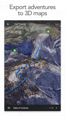
More About Footpath Route Planner
Join millions of adventurers using Footpath Route Planner and pave your own path.
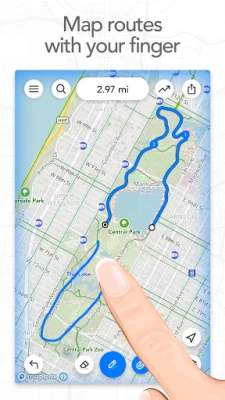
Snap to map
Quickly measure distances by tracing a map with your finger. Footpath will snap to any roads, bike paths, hiking trails, or paths you can find on Footpath's topo maps. Footpath can even snap to rivers and railroads.
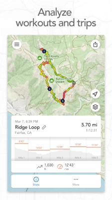
Measure distance and elevation
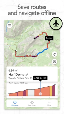
Know exactly how far and how high you'll travel with an accurate distance measure and detailed elevation profiles. Plan a precise route that matches your mileage goal, or use as a GPS distance tracker if you run without a plan.
Save routes for later
Marathon training or planning a backpacking trip? Sign up for a free account to save up to 5 routes at a time, or save an unlimited number of routes with Footpath Elite.
GPX viewer
Find a cool hiking trail on the web? Import GPX files from anywhere to analyze or save for later.
Share routes
Send your routes to friends or workout partners and let them partake in your adventure.
Footpath is designed to work in any country, and for any activity or adventure you can imagine:
• Running, walking, and hiking
• Cycling and mountain biking
• Motorcycling and driving
• Kayaking, canoeing, and standup paddleboarding
• Backcountry skiing
• Sailing
• And many more!
———
Footpath Elite
Ready to go the extra mile? Upgrading to a Footpath Elite subscription unlocks the following powerful features:
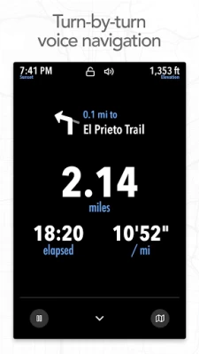
• Turn-by-turn navigation: Footpath will tell you when to turn with turn-by-turn audio cues
• Premium topo maps & overlays: including USGS Topo Maps, OpenCycleMap, bike paths, avalanche slope shading, elevation contour lines, and many more
• Offline map downloads: follow your route even without cell service
• Organize: save unlimited routes and sort routes into custom lists
• Export: export GPX files directly to Garmin Connect, Wahoo ELEMNT, COROS, and other apps
• GPS Devices: export TCX and FIT courses for turn-by-turn navigation on select Garmin and Wahoo running watches and cycling computers
———
Tips for mapping routes
• For a longer route, try zooming in and mapping your route in multiple segments.
• Tap and hold the map to quickly route between waypoints and POIs.
• Did Footpath snap to the wrong roads? Trace over the incorrect segment to edit, or use the eraser tool.
• Turn off snap to roads (magnet icon) and zoom in to manually trace the map. (Try switching to a satellite layer).
———
Contact Us
We've got a lot planned for Footpath. If you have any suggestions or feedback, or if you run into any issues, please contact us at support@footpathapp.com.
Latest Version
2.2.8
August 14, 2024
Half Mile Labs LLC
Internet
Android
717,808
Free
com.halfmilelabs.footpath
Report a Problem
User Reviews

JenR Old
2 years ago
I've been using this app on and off for over a year and subscribe to the premium version to add multiple routes it's priced just right for my budget. Footpath Route Planner is a wonderful tool to get me out of my sedentary funk. I like to plan routes the night before. Its no nonsense, just routes, and I appreciate the elevation graph. I would love to see the ability to add free text notes to a route so I can remind myself where there is a place to rest, go to the loo and refill water.

Orinoco Womble
4 years ago
Hold on a cotton picking minute..... Great idea to quickly plot a route, glad i signed up. Plotted a route,saved it....... And then, I can't follow it,can't see individual turns and can't use the voice turn system..... Unless I pay monthly installment,why would I do that if I don't know if the app is any good, and I NEVER subscribe,I may pay for something outright if it's good. Come on .... This really liked like a good app too. Definitely if your into subscription services then worth it.

Rizza
2 years ago
FootPath is a fantastic app for anyone who enjoys wandering around the city and wants to keep track of their route. Unlike other apps I've tried, FootPath allows me to track my route and gives my exact location in real-time, even if I don't have an internet connection or data. It's like having a personal guide with me whenever I go wandering, making it impossible to get lost. It's a great feeling to have my route mapped out. I can review my journey later to see where I went & how far I walked.

Iain Short
4 years ago
Really easy to map and track routes. I wish it had a light map when following a trail though... the dark one is too hard to see in daylight. Also, the UX when tracking is a little confusing if you want to do things like change which route to follow (e.g. weather improve and you want guidance from a longer variation).

Andy Holloway
1 year ago
Can't really fault the app as it has served me very well when creating highly customised cycle routes (e.g. cycling around tbe M25 - not on the motorway, of course - in both directions) for several years (paid version). However, I have received zero replies when making suggestions that would put the Android version of this app in line with the Apple version (e.g. 'view map' option). Developers, please communicate with your (loyal) customers even if you have no intention of updating this app.

Ike McClane
3 years ago
Amazing app, very well worth the money for the elite version. Easy to use. Tho I have issues every now and then. The issues I have are negligible, and could be due to user error. I work at a bike shop and always recommend this app for riders who are trying to plan trips on or off road. Easy to use and you can export the maps to a cycling computer, or use the app itself for those without a dedicated cycling computer. 10/10

Thomas Watson Hollingworth IV
3 years ago
Useless for established trails. There are huge portions of public lands and park trails that aren't included in searches. When I zoom in they're completely absent from the map, and my searches almost always route me along roads. In a walking app this seems like a major flaw. This information is available for free. If I just wanted to use roads I'd stick with Google Maps. Of course Google Maps and the US Forest Service app show trails and public lands, so I will be sticking with them anyway.

David Morrison
4 years ago
I love the way I can easily erase portions of tracks and add adventurous loops. I export fun looking rides from in Strava. Import them into Footpath and erase sections I don't want then loop back on boring sections to make the ride more adventurous then export that route into Locus Maps Pro for navigation. I know Footpath has navigation, but it's not as good as Locus Maps Pro. I only gave it 4 stars because there's a huge learning curve. Not very intuitive.

Elizabeth Brown
4 years ago
The free version is perfect for what I need. (looking to plan out walks/bike rides that are specific distances in order to hatch eggs in Pokemon go). it does exactly that in a very easy to use format. The app has lots of helpful options for users that pay an annual fee. Normally I hate paying to use apps but this app is the only exception.

Brian Corliss
3 years ago
I downloaded Komoot to plan running routes on my phone and after about 15 minutes of it producing the most absurd routes imaginable, I had to just delete it and try another. Found this app and had accomplished my goal within about 2 minutes. Super intuitive and easy to use. Highly recommend if you're just trying to quickly map a run and estimate distance, elevation, etc.

t ega
2 years ago
(this for free version) Ok app, easy to use and good for tracking runs. My main issue is it will occasionally jump distance, meaning it thinks I've gone further than I did. Several times I'll be about 4 minutes in and it will notify me of my first mile; I'm in decent shape, but not that fast. If that were fixed, or I had to ability to manually edit the data on my runs, I wouldn't care all that much.

Rob Oliver
3 years ago
Pros: Nice interface for route planning IMO. Cons: Can't navigate w/o "elite" version. Can't save or track route, can't even count steps or mileage without an account - too much dependence on the cloud in general for my tastes. This version uses 25MB. Not bad, but most valuable features are unavailable. Map data depicts lakes/ponds in my neighborhood that do not exist. I'm not willing to waste time and money to sign up for account and subscription to try.

Jose Gomez
2 years ago
Extremely useful app for creating your own custom made drawn routes for driving, walking, or biking. My favorite feature about this app is not having to look at my phone's screen at all - unlike a traditional GPS app. This app has a very well-made GPS talking feature. I will continue to pay the premium. Thank you for the trial and for creating this. My only real complaint is that I'm unable to use the GPS when turning off my phone's screen but maybe that is an issue with my particular device.

Eric
2 years ago
The app is OK, not greatest thing but not the worst. We do have the premium version for turn by turn directions. It sometimes will not navigate me correctly when doing repeats around blocks (it cuts me short by one lap). I haven't seen a decent upgrade in over a year where functionalities were added. Would like an option to repeat planned routes. When getting off route it oftentimes takes 30 seconds to send a correction prompt.

Melissa Sawyers
3 years ago
I LOVE THIS APP. I hate that the maps are not up-to-date though!!! Map My Run has up-to-date maps, but it does not have the features that I like with Footpath. Without up-to-date maps I cannot calculate my run distances very well when planning a new route. I live in an area with a lot of new construction so the map issue is a huge frustration. But I do like that I can make a new route on my phone and It is easy to create one. My favorite feature is the voice directions during my run.

PG
1 year ago
Not working, at all, after Nov 10th upgrade. Galaxy s23 Ultra. Previously had a horrendous bug. Trying to map route, if you came close to starting point, map would zoom out to full town zoom, forcing tedious zoom back to individual-streets zoom. I alerted Dev, months ago; no response. One of 2 apps to which I subscribed. Never again. Extra star bc it *was* great for years.

Sean Gerace
2 years ago
Probably the best route planner I've used. The path drawing is by far the most seamless I've seen, and five paths on the free version is very nice. I've been planning routes out for dog walking, as well as trying to get a sense of what routes are like before leaving the house, since I'm disabled and can only do so much. I'm extremely poor right now, but once I'm not I'll for sure be getting the premium version.

Steve Conlon
3 years ago
This is exactly what I had hoped for in an app. I paddle in the middle of nowhere so to speak and I am not only new to this area but 68yrs old. I do carry a phone with a tracker turned on but I've been afraid to venture upstream to who know where. Knowing how much farther a bridge may be or some kind of progress as I venture forward is invaluable. this app is perfect and so easy to use! I love it!

Adam Brasher
1 year ago
Finally cancelled my subscription to the premium version after a year as the app has just gotten buggier and buggier to the point of being unusable. Constant "timeout" errors when trying to create a route that makes the process incredibly time consuming, and random crashes while navigating without any warning or notification.

DavidPrice PSU
1 year ago
Simple, easy to use, does precisely what I hoped it would do. I've gotten a couple of timeout hiccups, but when I zoom in and/or make shorter entries, I have no problem at all. I particularly like that there are in-town trails on this, too, so I can venture off of my streets into a known local path. Altogether a superior product for my uses, which primarily is relatively accurately estimating the length of a walk or run in areas known to me.


