

Avenza Maps: Offline Mapping
July 02, 2024
More About Avenza Maps: Offline Mapping
Avenza Maps is free and the best map app for recreational use. Maps are available for free or purchase from the in-app Map Store. Plus subscription is available for unlimited custom map imports. Pro subscription is available for professional users with full access to all features and mapping tools.
Avenza Maps for your offline adventures on all trails!
ENHANCE YOUR MAPS WITH THESE FEATURES
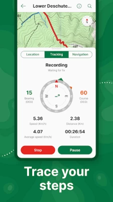
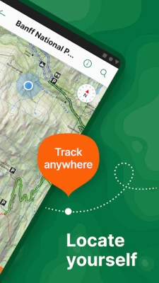
- Locate your realtime GPS position and find direction, even when offline
- Record GPS tracks during your activities
- Navigate to features using compass tools
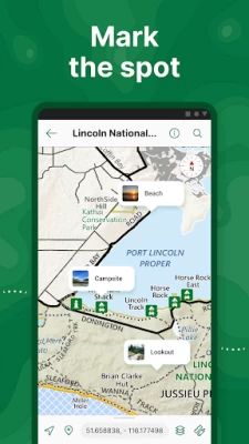
- Add photos and notes to any location
- Add placemarks to your map and style them with recreational symbols
- Measure distances and estimate times
- Supports KML, GPX, and CSV Formats
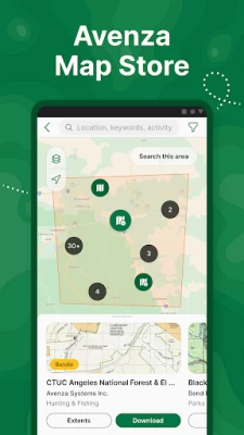
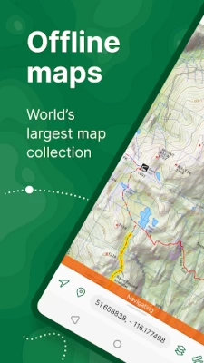
EXPLORE THE MAP STORE
Search and download maps by activity, category, and specific publishers with premium maps from:
- National Geographic
- Michelin
- Backroad Mapbooks (BRMB)
- New York-New Jersey Trail Conference
- USFS (United States Forest Service)
- USGS (United States Geological Survey)
- FAA (Federal Aviation Administration)
- NOAA (National Oceanic and Atmospheric Administration)
- BLM (Bureau of Land Management)
- HarperCollins
- DeLorme Atlas & Gazetteer / Garmin
- BaseImage
- National Park Service
- And thousands more!
A free account lets you access all of your map downloads.
GET MORE WITH AVENZA MAPS PLUS
For recreational and power users who need more
- Unlimited import of your own geospatial PDF, GeoPDF®, and GeoTIFF maps
- Create geofences for up to 50 individual features and up to four geofence layers
GET EVEN MORE WITH AVENZA MAPS PRO
For professionals and organizations who require an offline mapping solution with location awareness with more features and tools
- Unlimited import of your own geospatial PDF, GeoPDF®, and GeoTIFF maps
- GPS averaging, additional coordinate display formats, custom symbol sets
- Connect high-accuracy GPS devices including Trimble, Bad Elf, and Dual via Bluetooth
- Created unlimited geofences and get global geofence notifications
- Convert tracks to areas
- Map orientation lock
- Import and export Esri® Shapefiles
- Import and manage custom symbology sets
- Priority technical support
Avenza Maps Pro subscription required for commercial, academic, government, and professional use.
SUPPORT
We can help! Go to support.avenzamaps.com
LEGAL
Privacy Policy: avenzamaps.com/legal/privacy-policy.html
Terms of Use: avenzamaps.com/legal/terms.html
CONNECT WITH US
avenzamaps.com
facebook.com/avenzamaps
twitter.com/avenzamaps
instagram.com/avenzamaps
Latest Version
5.3.3
July 02, 2024
Avenza Systems Inc.
Internet
Android
5,322,231
Free
com.Avenza
Report a Problem
User Reviews

DD Butikofer
2 years ago
So far, so good. Haven't had a chance to use it much yet. The online maps that they provide are better and larger and seem to provide more detail. 5-17-19 ... It's turning out to be excellent, loving it! 4 stars have become 5 stars ! 3-9-22 ... Still doing great. Gathering maps from distant areas to make our vacations more interesting . 😉 With a new phone I do have to re-find and download all the maps I had before . 😟

Richard Follet
3 years ago
I like that some maps are free. Others are quite inexpensive. The USGS Topos are actual maps, some very up-to-date. App locates your position on the topo. Better than a paper topo map. I used to buy the paper USGS Topo maps for, like, $20 each. These are on the smaller screen format, but zoomable. So much more useful in the field, plus, the map will locate you. No more triangulation approximations.

Emerald Bixby
5 years ago
The maps are great, so is the selection, but that's a credit to the map creators, not the app. I use this often, glad to have it, but the UI is right out of the '00s. 1. Search functionality in map store sucks; you need exact keywords in the exact title of the map you're seeking, not just general terms. 2. You have to use in-app back buttons and not your phone's (what year is it?) or it takes you out of the store entirely and YOU HAVE TO REDO THE WHOLE SEARCH AGAIN. Useful, just needs work.

Russell Grange
4 years ago
Amazing tool for adventuring! I was about to buy a GPS device for hundreds of dollars, then discovered Avenza. Now I have the perfect tool to digitally access my favorite maps (it's worth paying for the quality maps!) and be able to see exactly where I am, even when I'm far off the grid and out of cell service. I can track my routes, track my progress, drop pins at my favorite campsites and so much more. If you love maps and love adventuring, this app is a fantastic.

A Google user
6 years ago
Updated review for newest version as of 12/14/2018: New version has tracking controls used while recording your route. The controls take up half the screen, limiting your ability to see what's on the screen, especially when zoomed in. Would be nice if they could be minimized/hidden. New version also seems to drain my phone battery much faster than before, even when in airplane mode. Now limits number of maps I can import. Unlock the feature for $29.99 a year? What a bunch of BS.

J. Kevin Mann
3 years ago
Great selection of maps. Many are free or low cost. Once you have a lot of maps downloaded you can group them in folders. The worst aspect of this app is finding the right map. There can be 20+ maps for an area with only one meeting your requirements. The map selection tool isn't very effective, and the map previews aren't very informative. It's often best to get a recommendation from someone else who already has a map that is working well for them for a specific area.

Nicholas Richardson
3 years ago
This is an excellent map app, probably the best that's available if you're an OHV user. The cart and search functions have been vastly improved over the years. Lastly the pro version is subscription based. I currently have no need to import maps which seems to be the main feature the subscription service adds. I wouldn't mind paying a one time fee to support these guys and their work on the app but I'm not interested in a subscription model at least for my use level.

DK NY
4 years ago
This isn't so much a mapping app per se (like Gaia or Maps.me) as it is a map store to buy maps published by others. There is a gazillion maps available for download costing up to $30 per map (and at least in one case over $100) BUT with many published years/decades ago. If you're looking for some highly specialized maps, it may work for you. But be prepared to do a lot of searching as l search functionality is very limited. Also, the app immediately tries to force you to create an account.
A Google user
6 years ago
Great for finding GPS while hiking without mobile service. I've downloaded it on my old phones too. I do have issues when trying to transfer my data from my old phone to a new phone. It's a pain in the ass. I dont understand why I cant just transfer a file with all of my maps and waypoints and pictures from my old device. I would pay extra for that. the app works great when I finally get it set up, but changing devices SUCKS

David G
3 years ago
4/5/2022 UPDATE Back to 5 stars because I'm super excited about this next update and because of the efforts (and investment) these folks are making for this major upgrade. Good job. OLD UPDATES: Dropping it a star from the last update. More confusing and difficult to find maps. The default screens are closed, filters reset each time, and not sure why I need my GPS on just to browse maps. The interface is more confusing. It still tracks well and the breadcrumb feature is awesome.

Collin Cowsill
1 year ago
You can download from a vast selection of regional maps for specific watersheds, forest reserves, and parks, all showing topographically significant features like service roads. The interactive beta map is the best part since you can view the entire swath of GIS in one screen, search features, and select/download specific maps for whatever area you choose.

Jonathan Ketner
1 year ago
Had to use it in snow to keep track of the trail. Since it was snowy I needed to take detours for the safest snow path and I could always trust to come back to the path later if I needed to. While a topo map is free the store options can work well too if it's a good vendor. The Nat Geo maps have important information that would not be on a topo map for example. Several National Park maps are free too.

Adrianne Black
1 year ago
The details on the map (i.e. the scale and the size of the icons) do not allow for enough specification to tell exactly where you are or where the trails turn. In addition, every PDF I try to open defaults to this app and I can't find a place to turn that off. As a result I can't read any other PDF I download.

Jeramey Brady
1 year ago
Edit: support eventually got with me, I see where to download it now, however it is more hidden than I would expect. Especially since you cannot download it at all once you are viewing the map. It can only be downloaded from the previously downloaded screen. Buy maps... change phones...loose maps that are "out dated" and removed at request of vendor... forced to buy again....not planning on buying again....not happy even with offered discount

Warren Cheng
1 year ago
Great for hiking. Download USGS topo quads, import custom kmls, put phone into airplane mode to conserve battery, and I'm set. I like how you can create one main layer and use it across all maps. It makes organizing data much easier. I'd like the ability to pin maps to the top as "favorites" though. That would be helpful.

Corey Bennett
1 year ago
It's very useful to be able to put your current location on pdf maps. I love having the motor vehicle use maps on my phone and being able to see where I am on those maps. So many different maps are available as pdf files... often for free or cheep. Being able to have them on your phone and pull them up with your location marked is so helpful. Avenza has many map mark up features and ability to import/export in multiple standard map file formats. Very helpful.

Sylvia M V
1 year ago
NEW It turns out that I had run into a bug, and they were very responsive about it, and actually were able to put out an APK that fixed the problem. I assume they'll fix it pretty soon in the play store version too. So, kudos to them. OLD It was great before, but I was on a much older version (which worked fine). Now, I downloaded the latest version, and I can't use the maps when offline. As soon as I open the app, I get a message, "You're offline, check your connection".

Logan H.
1 year ago
The app, overall, works fine. It constantly pesters me to upgrade, which is very annoying. I have to switch between maps frequently, and it can't go more than a few minutes without a dozen pop-ups in a row. One pop-up after initial start-up of the app is fine. Anything after that, especially a dozen times, is excessive. Maybe it's a bug. Really detracts from the apps overall usefulness. If they fix it, I'd say it's 5 stars.

Amparo Oxner
1 year ago
I love Avenza maps. You need service to download the maps. But after you have eye maps downloaded, it works really well even without cell service. I've walked many different Tennessee State Park trails including areas where there is not the closest bit of cell service and it works great! There is a downside that the GPS tracking doesn't always work as well if you are in a building or thick tree canopy. But as long as you have a good view of the sky, then it functions really really well.

Sean Required field cannot be left blank
1 year ago
This app is the bees' knees for field work. I'm sure there are better, but the free version, allowing you to upload up to 3 geo referenced .pdfs, is brilliant. The pro version is not worth the $155 USD, but as a student doing a field based project I took the plunge for a year sub. The diploma will erase the cringe of paying so much. For $30, I wouldn't bat an eye. The free version is painless to try and is certainly worth the cost of admission ($0). -1 for the high cost of pro.


