
Avare
June 18, 2024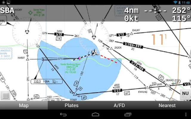
More About Avare
** No support in Reviews. **
** Please use our Friendly, helpful Support Forum. **
24/7 at: https://groups.google.com/forum/#!forum/apps4av-forum
**NOTE: Avare can't function fully until you turn on BOTH
of Avare's requested Permissions (Location & Storage).
Avare (pronounced "ah vAir" - like "aware" with a "v") is a free moving-map Aviation GPS & EFB app.
*Note: Internet access is required only for installing the free app, aviation Database, and at least 1 of the free charts; and for any updates. We recommend that you TURN OFF Play Store AUTOMATIC UPDATE for Avare, manually update it and all Downloads, then fly in Airplane Mode to save battery.
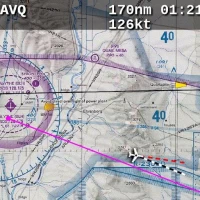
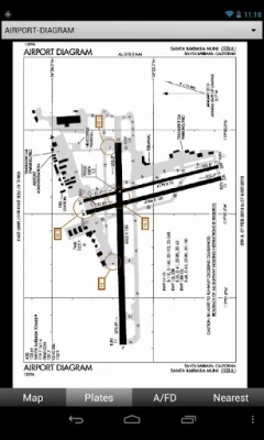
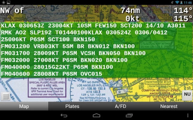
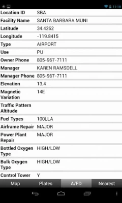
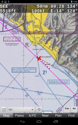
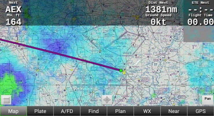
Avare offers offline moving map on all FAA charts (VFR Sectional, IFR lo/hi enroute, Approach Plate, WAC & TAC); plus A/FD info, Airport Diagrams w/GPS Taxi, and Terminal Procedures. Also: GPS status, Terrain/Elevation Maps, 50 Nearest airports, Obstacles, and more. Some FAA Charts cover Puerto Rico, plus parts of Canada, Mexico and the Caribbean. All of this is Completely Free with no ads.
*Note: Like all apps for portable devices, Avare is not FAA certified for primary navigation but may be used as outlined in FAA documents. See our NOTICE below, and the FAQ on our website for links to FAA documents.
Avare Advantages:
•Made by & for pilots
•Easy to learn & use
•Quick & responsive
•All free FAA materials & more
•Runs on most Android devices
•No ads or invasive permissions
More Features:
•Type in any address or coordinates.
•NOTAMS, METAR, TAF and Winds (Internet fetch or ADSB).
•ADSB TIS-B Traffic (UAT/1090), PIREP (free AddOn apps).
•Graphic & text TFRs (Internet fetch or ADSB).
•Canada topo, plus terrain maps for most of the world.
•External GPS, autopilot and flite sim options.
•Obstacles: Any over 500' AGL within 200' of GPS altitude.
•Frequencies, runways, fuel availability, & all A/FD info.
•13000+ GeoReferenced approach plates and taxi diagrams.
•Landscape/Portrait, North Up/Track Up (NU/TU) display.
•Draw notes on-screen, or Pan freely on charts (Draw/Pan).
•Long-Press any two points for approximate distance.
•Location icon Center, or track from your own placement.
•GPS compass direction, Bearing, and Distance to and FROM any point on the map by long-pressing one finger on that point. Great for your ATC and CTAF radio calls.
Avare installation begins with the small app, and then fetching an aviation Database and at least one chart. You can of course choose additional charts and materials for Avare to Download free at any time.
Note: The FAA occasionally changes their charts such that outdated charts may incorrectly display your location in Avare, so be sure to Update any charts you may use in flight! ANY time you plan to Update a chart, first ensure that you have the latest version of Avare and its Database.
After installing Avare, please use the Help feature to begin. New features are being added very quickly in response to user feedback, and may not be reflected in this Description page. You are invited to Contact us directly via our apps4av google group Forum to share your questions, feedback, and feature requests.
Launch Note: To access Help in the Avare app, on the Map screen tap the round Menu button, then the rectangular Help button at lower-left.
NOTICE: This software is provided "as is" and any express or implied warranties, including, but not limited to, implied warranties of merchantability and fitness for a particular purpose are disclaimed. In no event shall the copyright holder or contributors be liable for any direct, indirect, incidental, special, exemplary, or consequential damages (including, but not limited to loss of use or data) however caused and on any theory of liability, whether in contract, strict liability, or tort (including negligence or otherwise) arising in any way out of the use of this software, even if advised of the possibility of such damage.
Latest Version
10.3.2
June 18, 2024
Apps For Aviators
Internet
Android
423,973
Free
com.ds.avare
Report a Problem
User Reviews

A Google user
6 years ago
A good app for general use. Most basic functions work well. I finally got it to sync to my Dynon SkyView for weather and traffic display from ADSB. It still has a problem with the ADSB traffic display. I think it's displaying everything with pressure altitude. instead of relative altitude. You have to do the math in you're head to know if that nearby traffic is above or below you. Only other complaint is minor. I'm not a fan of the color coded TAF reports. Very distracting.
A Google user
6 years ago
great app! best I have used! I always flight plan using charts in case I lose gps signal. I have never lost signal on this app and it has always been accurate. The aircraft I rent has a Garmin 496 but I prefer to use this app on my Samsung S9+. It is easier to set while in the air and takes less of my attention away from flying and watching for other aircraft. I have been using this app for a couple of years and have made quite a few cross country trips of 200 miles or more with no failures.
A Google user
3 years ago
Update: I have been using Avare for a couple of years. I have still never had a problem with it. I set up Paypal to send them a donation every month, and it has been more than worth it. Update: Mark Hissey mentioned that he lost his saved flight plans during an upgrade. Apparently, I did, too. I didn't have as many as Mark, but that really sucks. My rating will stay the same, but hopefully this problem will be fixed.

Chris Petersen
4 years ago
This app is fantastic. I was flying a very primitive C150 without navs and used this app to locate my distant airport an hour away. I was a bit skeptical at first, but after testing its accuracy for the first few minutes, I was convinced it was the real deal... and it was. The app guided me perfectly as if I was using a modern GPS. I will use this app all the time now. Love it!
A Google user
7 years ago
This is an app for pilots. I've been flying with it for about 2 years, and I love it. It's just the basics - moving map, simple flight planning, etc., but it's easy to use and reliable. Simple and free chart and weather updates. I use it for vfr in the ne us, where there is a lot going on, and it's a big help in maintaining sa.

Leland Lee
5 years ago
This app works wonders. I use the Garmin Glo GPS with it when I'm above cell reception altitude. My only complaint is that the weather charts don't all work or load for some reason (AIRMETS, Low and Mid Level Prognostic charts, and all those under the Turb and Icing tabs) even after updating the data from the Downloads section. The weight and balance is difficult to use even after going through the tutorial. With a few minor tweaks and enhancements this could be an even better app.
A Google user
6 years ago
I love the app i would give it 5 stars but I cannot figure out how to turn it off. The navigation is always on and I have gone through everything trying to figure out how to turn that part off. It is always on and very quickly drains my battery and I get all kinds of CPU warnings because of it.and because of that i had to delete it and go with somthing else to get my sectional charts. it's a great app and I love the sectional charts. In my opinion needs to be more user friendly
A Google user
7 years ago
Good app with geo-referenced plates for free (Foreflight charges extra for that feature!). Good feature set for the price (free), but the UI is clunky. I personally only use it if my iPad isn't handy and I need to do some light flight planning. I also use it for the Geo-referenced plates during approaches, but would never use it as my primary EFB.
A Google user
7 years ago
Finished my PPL this year and built a Stratux. The I/o thing is clunky. But once it connects we get traffic, etc. My tablet is just a POS and has me thinking about getting an iPad... Areas of improvement would be auto connect to Stratux, reinitialize the ahrs, flight planning, wx briefing, etc. So many features in fore flight that are tempting me away from this software. I can't really find a use for it in the cockpit other than back up GPS and adsb traffic in. It's just clunky.
A Google user
6 years ago
I've been using Avare for years now. The interface is clean and clear. Easy to use and it's free!. However, the saving of the kml track doesn't work 95% of the time. ADSB traffic shows but there's no way to select a target to see details. So I run another paid app to track my flight and monitor ADSB traffic while I use avare for the chart only.
A Google user
6 years ago
I have an Android tablet that is so lame that is can not be used for internet however it works great for the Avare map app. I practiced using the app on my living room couch until I learned how to use well. Then today I used it in flight. It is awesome to use. I had low clouds so I had to fly low so finding all tall structures and antenna towers was necessary for safety. The map can be made larger easily so you don't miss the details bouncing around in the rough air. There is a dashed line that shows your future track and I turned on the distance circles which stay around the aircraft while you travel so you can see how far you are away from that tall radio tower. If you forget what runways are at your destination airport just look at your map and you will see the red arrows that not only show the direction of the runway but the number of each.. I am still learning to use it but so far this program is the best. I do have paper charts for a back up but this beats paper hands down. Try opening and refolding a map in a 24 inch wide cockpit is no fun. Thank you for making this product. It has for sure improved the safety of my flying.

Sam W (sjweikart)
2 years ago
A very powerful and free navigation / flight planning software. Only complaint is that it has an "open source feel" meaning that there is a lot of stuff to use but it can be slightly confusing. I used this on a 600nm trip and it worked great. Just make sure to keep the app up to date and download whatever sectionals you need before your trip. The last big selling point is that you can use it out of cell range. You won't get real-time data other than location, but nav and saved data works great.

Doug Schrag
4 years ago
It is a simple, easy to use, extremely powerful app that is very stable and rarely if ever crashes. it is easily my favorite aviation app. Totally free including updated maps and plates every cycle. The approach plates are geo-referenced right down to the automatic switch to the airport diagram on rollout. I can't say enough good things about it! Just a truly amazing app!

Chris Rudisill
4 years ago
I really like the app. I've been using it for 2 years now. Today I added a Stratux receiver to give me traffic on it. Only problem is that as of the last update, any time I open a different window on my device it loses all of the data and have to reenter the flight plan. Hope they fix it quickly. Edit: Thanks for the update! Solved the restart problem!
A Google user
6 years ago
This is a great go to when I don't have my iPad with my Garmin GPS. For a free app., it does all my basic needs. Once I configured to my screen with the options I like, it gives me most of the info. I need. I used this the other day in the back of my friends RV8. There are no instruments back there, and I was able to navigate with approximate airspeed, altitude and stay clear of airspaces with Avare. Since he did not have any ADSB equipment, my iPad was worthless, so this worked like a charm.

Randy Seiler
4 years ago
PILOTS - Don't pass this one up!! Put this app on your android tablet or phone, down load the maps, and you'll always have a FREE backup to Fore Flight or Garmin Pilot. Where else can you get a backup nav app for FREE? I've used this app for VFR flying many years and never had a problem with it. It's easy to get chart downloads and updates. it's intuitive and takes absolutely no time to learn. Give it a try and if you don't like it just uninstall it an you've lost nothing.

Mark Hubelbank
2 years ago
I use this as a backup for for flight. It allows a completely independent system to be available for IFR flight in addition it can be used as a second display to just show the plates on one display and maps and everything else on another. It allows one to do this with a very inexpensive Android based system. In addition there is no obvious cost to it. Perhaps they have started to ask for donations and I will gladly provide them.

Joseph Paroulek
5 years ago
Excellent EFB app. This is an open source app so it is truely free and is supported by volunteers. It has all the basic functions I need as an instrument rated private pilot. Map screens are not cluttered and you can select just the maps and coverage you need. Updates of maps and weather are easy one button push and downloads are fast. Works well on both my Samsung phone and tablet. I have been using Avare on my tablet with the stratux adsb receiver. I get in-flight traffic, METAR and NEXRAD.

Wayne Foster
1 year ago
Avare is a great free product/app for pilots looking for a navigation app with all the features found in other products that you would otherwise have to pay for. Traffic alert, weather info, maps for vfr and ifr, plates, supplemental info, and many many other features exist within the Avare app. I am able to plan a flight, and it also has filing capability although I have not tried filing a plan there yet. To appreciate what the Avare app has to offer each pillot needs to try it for themselves.

khalid Shuwayhat
1 year ago
Excellent , easy to use ,good tutorial on you tube , ADS-B works well , a quick hint from Uavionics for echo UAT helped. waiting now for rs232 Bluetooth to test autopilot. on my Galaxy Note 8 it works like a breez smooth fluid flow map and menus. I love it. I have also Iflygps, the 2 are comparable except iflygps The omitted NMEA out on the download version !!! if the Auto pilot works ok the I shall get rid of iflygps. Also the EFIS diplay works well and stable due to the good quality hardware of the galaxy note 8, no need for external AHARS , the note 8 has excellent sunlight reada bke screen and big processing power that make the Avare run smooth, and best it's free. I'm happy to Donate for further development. Great work .


