
All-In-One Offline Maps
July 23, 2024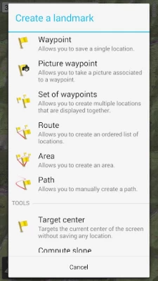
More About All-In-One Offline Maps
• Want more than just roads on your maps? You will find what you need here;
• Used to go to places with poor network coverage? Everything will stay available;
• Used to go abroad? You won’t be lost anymore;
• Have a data allowance limit? It will reduce your usage.
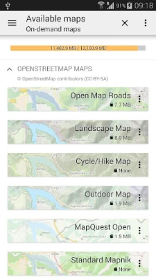
★★ Maps ★★
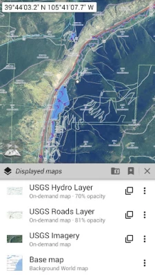
A lot of maps are available, including classical road maps, topographic maps, aerial (satellite) maps and various layers that can be added over any maps: OpenStreetMap (Roads, Topo), USGS National Map (Hi-res topo, Aerial imagery), Worldwide Military Soviet topo maps, etc.
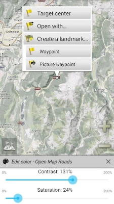
• All maps can be stacked in layers, with precise opacity control;
• Select and store large areas in few clicks;
• Stored space is clear and can be easily deleted.
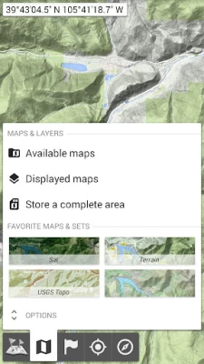
★★ Display, store and retrieve unlimited placemarks ★★
You can add various items on the map such as waypoints, icons, routes, areas and tracks.
You can easily manage them using the powerful SD-Card Placemarks Explorer.
★★ On-map GPS Location & Orientation ★★
Your real location and direction are clearly displayed on the map, which can be rotated to match your real orientation (depends on device capabilities).
Easy turn on/off to save battery.
And also:
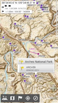
• Metric, imperial and hybrid distance units;
• GPS Latitude/Longitude and grid coordinate formats (UTM, MGRS, USNG, OSGB Grid, Irish Grid, Swiss Grid, Lambert Grids, DFCI Grid, QTH Maidenhead Locator System, …);
• Ability to import hundreds of coordinate formats from https://www.spatialreference.org;
• On-map grids display;
• Full screen map view;
• Multi-touch zoom;
• …
★★ Need more? ★★
If you are a real adventurer, try AlpineQuest Off-Road Explorer, the complete outdoor solution based on All-In-One OfflineMaps, loaded with a powerful GPS Track Recorder and more: https://www.alpinequest.net/google-play
Latest Version
3.15c
July 23, 2024
Psyberia
Internet
Android
7,392,180
Free
net.psyberia.offlinemaps
Report a Problem
User Reviews

_20o_
1 year ago
Very useful as offline maps but the downloads aren't partially downloadable. So if I get to 99% of a multi gig download and lose internet, its all gone.

Paul Haxby
1 year ago
A good navigation app that allows the use of various maps for walking and cycling. Not completely user friendly and this is my only reason for giving it a 4 star reason. I purchased extra maps and I used it to find my way in a remote area in forest tracks in a forestry commission site in the Lake District, UK. Excellent, but does take a bit of getting used to.

सायिलक्ष्मण
1 year ago
Limited zoom only, I don't know why google maps allow larger zoom than your app (but this only true for SOME areas, not for all). Also, a bug: sometimes I want to view full-screen version of image files, associated with placemarks. I try to set my favorite Image viewing app as default. But this setting isn't remembered by your app unfortunately.

Yayah Barrie
1 year ago
Very good app with qualities. But my problem with the application is; when you track a location in a sea, along the line going, why it doesn't display any object like boat showing the systematic moving?? I think it will be more fine and confidential. Thanks!!!

Hania Okunowska
1 year ago
The best offline map! It has all the things needed for any journey. It has totally free features and is better than most similar apps! App is fantastic for hiking, cycling and more. I recommend installing it.

SKS
1 year ago
A handy tool which is indeed useful with its interfaces. It has definitely improved since last year and is a working option that is reliable for providing quick planning and execution. However, the 'Dynamic Profile View' is Unsatisfactory. It does not give an Elevation Profile along the route. It just shows the Slope from the Origin to Destination. Can be improved to be a competitive option.

Charles Davidson
3 years ago
I've had this app on two different phones before and loved being able to download maps of different kinds , but unfortunately it is no longer usable with this new phone and new network !!! Can no longer download and save anything !!! I have wasted a lot of time and data doing exactly as I used to be able to do with my old phones but Everytime I save anything it is lost , and it is no longer available to save to SD card ether !!!

A Google user
6 years ago
Feature Packed!! This application is many types of map applications in one package. It can show you road maps, topographical maps, USGS maps, and more. You can pick Imperial measurements, Metric or a hybrid of both. One can not only layer various maps, but chose the opacity for each layer. It coordinates your GPS position grid with your choice of several (USNG, UTM, OSGB Grid & more).________________ Note that is is not what is often called a "Navigation App" in the sense that one enters a destination & gets a route. But it does track your path with GPS. ___________ Saving an area of a map is a little tricky at first, but once it's learned- it becomes intuitive.. (Their Alpine Quest web site explains well.) Note than One does not save an entire map, such as "Canada", but the part of the map that is of interest. Maps download rather quickly. --------------- I had trouble figuring out how to use parts of this app, so I wrote the developer. A person actually answered my inquiry (rare for a Play Store app) with helpful information. The person gave me links to easy instructions. (Note that instructions on their site are titled for Alpine Quest, but work for this app too. That's why I got lost looking for them.) ______________ About Ads- I have not seen one yet! _____________ The application does what is says it will, even on my ancient Android 5.1 phone and the developer is responsive to questions- So 5 Stars!

Jason H
2 years ago
I have been using HuntStand for my hunting Maps, but this app solves every problem I have experienced with HuntStand. Most of the map layers I needed were already included, such as USGS contours, and USFS trails and roads. But the real selling point of this app is it's ability(with paid add on) to import KML data. I have added KML layers that other apps struggled to load. The learning curve is steep, but with enough use you start to figure out all the functionality this app provides.

Jacqueline “MONKEY” Meares
5 years ago
I love that I have the USA map so handy, cause my man is a Class A Truck Driver and usually has meats with the fridge trailers. We're both from CA and couldn't remember the State Abbreviations (I couldn't even remember most of the states locations. I like the interstate and road & traffic, and terrain and other view options. Just wish I could get better directions on using all of the options available, somethings ice changed but can't get them back to the default settings.

Hugues de Lassus Saint-Geniès
2 years ago
An excellent free preview of the amazing and affordable AlpineQuest app as well as some other apps from developer Psyberia. Very powerful app with tons of customizations possible like map sources, map layering, track drawing, waypoint setting, etc. The main selling point to switch to AlpineQuest being altitude/elevation profile data, but OfflineMaps is just great to get a totally free first time experience of the user interface. Thanks for sharing your work, Psyberia.
A Google user
7 years ago
This is the only Map application I use and I love it. First I save a map of my whole work area and then I always have my maps even when I have no network or WiFi access. My job depends on me knowing where I am and where I'm going, so this is the most important app on my device and it never lets me down. I'd recommend this app to anyone looking for a complete offline map with plenty of additional options to make getting there a bit easier.

David Dong
2 years ago
Great app! kudos to the development team! I have only one request: wish a precise control of download area. Currently, I can select square and how many layers deep from the top. if can draw freely on the map to select areas, also toggles to select layers will be great! I'm preparing for a rally race, LAB2V, to get all the sat map will take 760GB, wish can get only last layer to see the trails, and only the maps arond the trail area, thanks again for the great app!!!

Electronics & Projects 2020
5 years ago
This is the best map app I've ever used. I've used it for years and it's always worked in the woods without internet. I have only one suggestion, maybe you could make the download speed a little faster because my wifi can download at 10MBS and its only doing it at like 1 or 2. Also, maybe you can have an agreement with google to save Google maps that would be awesome. Great app, keep up the good work!

Leith “Leithal” Cassone
5 years ago
I've been trying GPS apps. I backed one on Kickstarter, that always seems to have issues. I took a quick look at this and I liked what I saw, then I started digging. This is the first app that I have used that accurately shows me what is downloaded easily. One other rquires me to toggle in and out of on-line mode to look. it's annoying. Everything is well thought out. I love it. Spend some time looking at it and you will be impressed.

Kent Schrader
5 years ago
By far this is the best mapping app I've ever seen. It's fast, complete, flexible, accurate, etc etc..So many maps to choose from. Never a crash. I've marked all my kids' homes on it as waypoints. I could write for an hour telling all the positives. Here are the negatives: // . Keep up the spectacular work, guys & gals!!!! Thank you for making a mapping program I can use even when I don't have an Internet connection!!!!!!

M. L. Adams
4 years ago
One you've learned how to use it, this is a great tool if you're going somewhere with bad or no internet access, especially since you can preload topo and satellite maps as well as road maps from several sources. A feature I'd like to see added is a way to enter a lat/long and have it show that location. Can't search for a street address; I don't know if that's even possible since the maps are downloaded as raster images. Still, some folks will find this app VERY useful.

Ernie Ayuluk
1 year ago
I like this app since I can mark with unlimited points of places I usually go or places I need to check. But the only star I could have marked on the featured map is that you set certain areas of the map with old blurred out, out dated photo of the map. Hope this gets resolved. Other than that thumbs up👍. It would improve the map if you would get rid of the winter terrain map. Other than that this is the one go to offline map I use. Thank You Very Much to the creators. PLUS lose the winter mode

Caden Omer
1 year ago
This app is amazing. You get access to all sorts of types of maps to facilitate pretty much any adventure you could come up with. On top of that, most have downloadable tiles, and you can toggle how zoomed in you want the downloaded sections to be. I haven't figured out yet if there's a function that could track a route, but that's pretty much the only thing I've wanted but couldn't find.

Mike Marshall
1 year ago
Way too complicated. It went from dozens of ways to customize to thousands! Not intuitive to use and takes hours to figure out the simplest things. I just want to download a basic map to use offline. This isn't it! A good program has basic features on the surface with advanced features buried. This starts with advanced features and is unusable until you learn everything !


